Kings Canyon National Park
Other natural features include multiple 14,000-foot (4,300 m) peaks, high mountain meadows, swift-flowing rivers, and some of the world's largest stands of giant sequoia trees.
Although John Muir's visits brought public attention to the huge wilderness area to the east, it took more than fifty years for the rest of Kings Canyon to be designated a national park.
As visitation rose post–World War II, further debate took place over whether the park should be developed as a tourist resort, or retained as a more natural environment restricted to simpler recreation such as hiking and camping.
[6] Kings Canyon National Park, located on the western slope of the Sierra Nevada to the east of the San Joaquin Valley, is divided into two distinct sections.
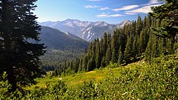
The larger eastern section, which accounts for the majority of the park's area, is almost entirely wilderness, and contains the deep canyons of the Middle and South Forks of the Kings River.
Ice Age glaciations did not extend all the way to the confluence of the Middle and South Forks; consequently, the canyons downstream of Cedar Grove and Tehipite are typical V-shaped river gorges, in contrast to the U-shaped valleys upstream.
It is situated on the south fork of the Kings River, above the most extensive groves and forests of the giant sequoia, and beneath the shadows of the highest mountains in the range, where the cañons are deepest and the snow-laden peaks are crowded most closely together.
The bottom of the valley ... is diversified with flowery meadows and groves and open sunny flats, through the midst of which the crystal river, ever changing, ever beautiful, makes its way; now gliding softly with scarce a ripple over beds of brown pebbles, now rustling and leaping in wild exultation across avalanche rock-dams or terminal moraines ... From this long, flowery, forested, well-watered park the walls rise abruptly in plain precipices or richly sculptured masses partly separated by side cañons baring wonderful wealth and variety of architectural forms.
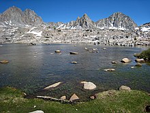
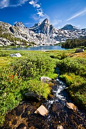
[19]: 147 Elsewhere in the high country, the landscape of bare rock and talus left by former glaciers is replete with hanging valleys, waterfalls, serrated ridges (arêtes), cirques, and hundreds of alpine tarns.
In a 1910 article in Out West, Ernestine Winchell describes the falls and Tehipite Valley: ... We paused a moment at the colossal doorway where Tehipite, shimmering through spaces of summer sunshine, in peaceful grandeur compelled our reverential gaze ... Across the river and below the dome Crown Creek races in sparkling cascades to grind a score of horrible pot-holes big enough to swallow a horse and rider; leaves that ferocious task to foam lightly down a cliff as Silver Spray Fall, whirls lazily at its foot, and then hurries to join King's River in its journey to the desert.
[28] Snow accumulations in the higher areas of Kings Canyon National Park can be extremely large, often totaling in the hundreds of inches, although the annual snowpack fluctuates greatly between wet and dry years.
According to the United States Department of Agriculture, the Plant Hardiness zone at Cedar Grove Visitor Center at 4,613 ft (1,406 m) elevation is 8a with an average annual extreme minimum temperature of 12.3 °F (−10.9 °C).
Birds such as gray-crowned rosy finches and American pipits, and sensitive amphibian species such as mountain yellow-legged frogs and Yosemite toads, feed on insects near alpine lakes and wetlands.
In 1917 the federal government began to crack down on illegal grazing and established a system of regulated management and range restoration, before sheep were banned from Kings Canyon altogether following the park's creation in 1940.
Although the culling reduced deer numbers to a more ecologically stable level, the program was criticized for its reliance on brute force rather than more "hands-off" methods, such as re-introducing predators.
[47] Today, the only stock allowed in the park are pack horses and mules, which are only permitted in certain areas along major trails, and usually not early in the season in order to protect meadows in the spring while they are wet and soft.
[66] After failed attempts to summit Mount Whitney, the Brewer party descended into the Kings Canyon via Native American paths where "they remarked its resemblance to the Yosemite and were impressed by the enormous height of its cliffs.
A hundred peaks in sight over thirteen thousand feet—many very sharp—deep canyons, cliffs in every direction almost rival Yosemite, sharp ridges inaccessible to man, on which human foot has never trod—all combined to produce a view of sublimity of which is rarely equaled, one which few are privileged to behold.
Daniel K. Zumwalt, an agent for the Southern Pacific Railroad – which owned many lumber interests in California – may have seen the park as a way to force their competitors in the Sequoia-Kings Canyon area out of business.
[34][74] For many years the primary way for tourists to reach General Grant National Park was the Stephens Grade, a rough wagon road over which a stagecoach operated from Visalia beginning in the early 1900s.
Due to its heavy flow and long drop – 11,000 feet (3,400 m) in less than 80 miles (130 km) – the Kings River has considerable hydroelectric potential, and reservoirs were proposed for Cedar Grove, Tehipite Valley and Simpson Meadow, among other sites.
Starting in 1937, large campgrounds were developed in Kings Canyon by the U.S. Forest Service, but construction of more permanent facilities was foregone since the area would lie at the bottom of one of the proposed reservoirs.
[81] Ultimately, local opposition to Los Angeles' attempts to secure the Kings River turned into significant political pressure to create a national park, which would prevent any dam projects there.
[82] However, in order to placate the local irrigation districts – who wanted to leave open the option of reservoirs – Cedar Grove and Tehipite Valley were specifically excluded from the new park.
[4] Demand increased for tourist facilities at Cedar Grove, the terminus of the state highway – although the valley was not officially part of the park, having been omitted due to water-development interests.
The closest and most heavily used eastern approach is via Onion Valley Road, which terminates about a mile (1.6 km) east of the park boundary in the Inyo National Forest.
A notably challenging route is down Enchanted Gorge in the Middle Fork backcountry, where Disappearing Creek vanishes under huge talus piles only to re-emerge several miles downstream, hence the name.
[121][15]: 285 Because of the park's size, lack of cell reception and limited personnel for search and rescue operations, only experienced cross-country travelers should attempt to hike off trail.
[125] In order to protect riparian habitat, the gently flowing South Fork is closed to boating in Cedar Grove between Bubbs Creek and the western boundary of the park.
Canoe Kayak magazine describes the Middle Fork run, which passes through some of the most isolated parts of the Sierra, as "the very definition of epic with paddlers traveling around the world just to make a once-in-a-lifetime descent".