Monte Rosa
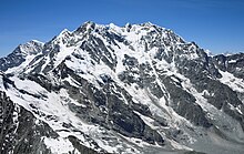
[1][4][5] The north-west side of the central Monte Rosa massif, with its enormous ice slopes and seracs, constitutes the boundary and upper basin of the large Gorner Glacier, which descends towards Zermatt and merges with its nowadays much larger tributary, the Grenzgletscher (lit.
The Grenzgletscher is an impressive glacier formation between the western wing of the mountain and Liskamm, a ridge on its southwestern side on the Swiss-Italian border.
On the eastern side, in Italy, the mountain falls away in an almost vertical 2,400-metre-high (7,900 ft) wall of granite and ice, the biggest in Europe, overlooking Macugnaga and several smaller glaciers.
Following a long series of attempts beginning in the early nineteenth century, Monte Rosa's summit, then still called Höchste Spitze (lit.
In standard German, the name Gorner is still used for the western ridge protruding from the main mass (Gornergrat) and the glacier that lies at its foot (Gornergletscher) but not used for the mountain itself anymore.
Monte Rosa cover areas on both sides of the border between the Swiss canton of Valais and the Italian regions of Piedmont and Aosta Valley.
The southeast face, culminating at the Signalkuppe, overlooks the piedmontese Valsesia and the Val de Gressoney in the autonomous region of Aosta Valley.
The ridge called Weissgrat connecting the Nordend with the Schwarzberghorn (Italian: Corno Nero) presents a wall of formidable precipices towards the east, but falls away in a gentle slope to the west.
The Gornergrat summit, lying 8 km (5.0 mi) on the north-west at 3,100 metres (10,200 ft), is a popular viewpoint of the massif, since it is accessible by train from Zermatt, using the highest open air railway line in Europe.
The extended range of Monte Rosa, which appears to originate in the intersection of two axes of great elevation, throws out a number of ridges that radiate afar and gradually subside into the plain of northern Italy, covering a relatively large area.
[2] On clear days the mountainous massif of Monte Rosa provides a striking view from the Po plain, particularly its upper reaches in western Lombardy and eastern Piedmont.
It dominates the horizon, towering between other lesser Alpine peaks as a prominent, multi-pointed, razor-sharp bulge, its permanent glaciers shining under the sun.
The summit is a sharp, jagged edge of mica schist connected by an arête with the Nordend, but cut off from the Zumsteinspitze to the south by nearly vertical rocks about 120 m (390 ft) in height.
[12] Owing to the frequent prevalence of a high wind from the east or north-east, and the slow pace at which it is possible to move when near the top, precautions against cold are particularly necessary when climbing Monte Rosa.
Plateau Rosa, about 3,500 metres (11,500 ft) high above sea level, is a summer ski resort, with snow all year round due to the altitude.
Gressoney, Champoluc, Alagna Valsesia and Macugnaga (under the east face, intensely glaciated and 2,500 metres (8,200 ft) high) are the main mountain and ski resorts that surround Monte Rosa along its southern side.
Monte Rosa is not technically difficult to climb, but can be quite dangerous due to its great altitude and sudden weather changes, as well as crevasses in its extensive glaciers – one of the major glaciated areas in the Alps.