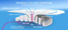
Eye (cyclone)
It is surrounded by the eyewall, a ring of towering thunderstorms where the most severe weather and highest winds of the cyclone occur.
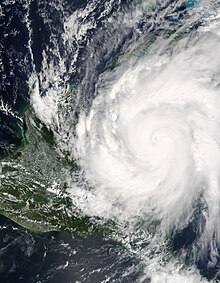
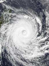
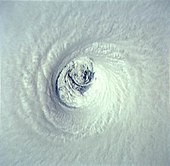
[1] In strong tropical cyclones, the eye is characterized by light winds and clear skies, surrounded on all sides by a towering, symmetric eyewall.
In weaker tropical cyclones, the eye is less well defined and can be covered by the central dense overcast, an area of high, thick clouds that show up brightly on satellite imagery.
[5] Eyewalls are typically circular; however, distinctly polygonal shapes ranging from triangles to hexagons occasionally occur.
Storms with pinhole eyes are prone to large fluctuations in intensity, and provide difficulties and frustrations for forecasters.
[12] This results in the formation of an upper level anticyclone, or an area of high atmospheric pressure above the central dense overcast.
Outside the forming eye, the anticyclone at the upper levels of the atmosphere enhances the flow towards the center of the cyclone, pushing air towards the eyewall and causing a positive feedback loop.
Air begins to descend in the center of the storm, creating a mostly rain-free area – a newly formed eye.
Scientists do not know why a ring of convection forms around the center of circulation instead of on top of it, or why the upper-level anticyclone ejects only a portion of the excess air above the storm.
Observations from ships and hurricane hunters can pinpoint an eye visually, by looking for a drop in wind speed or lack of rainfall in the storm's center.
In the United States, South Korea, and a few other countries, a network of NEXRAD Doppler weather radar stations can detect eyes near the coast.
Weather satellites also carry equipment for measuring atmospheric water vapor and cloud temperatures, which can be used to spot a forming eye.
Mesovortices can spawn rotation in individual convective cells or updrafts (a mesocyclone), which leads to tornadic activity.
[21] These tornadic circulations in the boundary layer may be prevalent in the inner eyewalls of intense tropical cyclones but with short duration and small size they are not frequently observed.
[27] Their development at the middle levels of the atmosphere is similar to the formation of a complete eye, but the features might be horizontally displaced due to vertical wind shear.
[28][29] Though the eye is by far the calmest and quietest part of the storm (at least on land), with no wind at the center and typically clear skies, it is possibly the most hazardous area on the ocean.
[30] A common mistake, especially in areas where hurricanes are uncommon, is for residents to exit their homes to inspect the damage while the calm eye passes over, only to be caught off guard by the violent winds in the opposite eyewall.
Like tropical cyclones, they form over relatively warm water and can feature deep convection and winds of gale force or greater.
Despite these differences, they can be very similar in structure to tropical cyclones, featuring a clear eye surrounded by an eyewall and bands of rain and snow.
Almost all storms found at mid-latitudes are extratropical in nature, including classic North American nor'easters and European windstorms.
The most severe of these can have a clear "eye" at the site of lowest barometric pressure, though it is usually surrounded by lower, non-convective clouds and is found near the back end of the storm.
[36][37] Certain single-vortex tornadoes have also been shown to be relatively clear near the center vortex, visible by weak dBZ (reflectivity) returns seen on mobile radar, as well as containing slower wind speeds.
[38] NASA reported in November 2006 that the Cassini spacecraft observed a "hurricane-like" storm locked to the south pole of Saturn with a clearly defined eyewall.