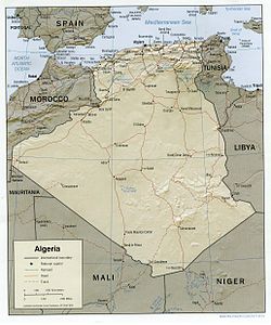
Geography of Algeria
Algeria comprises 2,381,740 square kilometres (919,590 sq mi) of land, more than 80% of which is desert, in North Africa, between Morocco and Tunisia.
[2] The northern portion, an area of mountains, valleys, and plateaus between the Mediterranean and the Sahara Desert, forms an integral part of the section of North Africa known as the Maghreb.
[2] Stretching from the Moroccan border the Tell Atlas, including the Djebel Babor formation, is the dominant northwestern mountain range.
[2] In its southern sector, the steep cliffs and long ridges of the Aurès Mountains create an almost impenetrable refuge that has played an important part in the history of the Maghrib since Roman times.
[2] The coast is predominantly mountainous in the far eastern part of the country, but limited plains provide hinterlands for the port cities of Bejaïa, Skikda, and Annaba.
[2] The Algerian portion of the Sahara extends south of the Saharan Atlas for 1,500 kilometres (930 mi) to the Niger and Mali frontiers.
[2] Much of the remainder of the desert is covered by rocky platforms called humud (sing., hamada), and almost the entire southeastern quarter is taken up by the high, complex mass of the Ahaggar and Tassili n'Ajjer highlands, some parts of which reach more than 2,000 metres (6,600 ft).
[2] Surrounding the Ahaggar are sandstone plateaus, cut into deep gorges by ancient rivers, and to the west a desert of pebbles stretches to the Mali frontier.
[2] The southern zone of the Sahara is almost totally arid and is inhabited only by the Tuareg nomads and, recently, by oil camp workers.
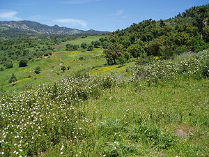
[2] Barren rock predominates, but in some parts of Ahaggar and Tassili n'Ajjer alluvial deposits permit garden farming.
[7] A prominent feature of the climate in this region is the sirocco, a dusty, choking south wind blowing off the desert, sometimes at gale force.
[7] In Algeria only a relatively small corner of the Sahara lies across the Tropic of Cancer in the torrid zone, but even in winter, midday desert temperatures can be very hot.
[7] Rainfall is fairly abundant along the coastal part of the Tell, ranging from 400 to 670 mm (15.7 to 26.4 in) annually, the amount of precipitation increasing from west to east.
[13] In the mid-1970s, however, the government embarked on a vast reforestation program to help control erosion, which was estimated to affect 100,000 cubic metres (3,500,000 cu ft) of arable land annually.
[13] By the early 1980s, the desert had already penetrated the hilly gap between the Saharan Atlas and the Aurès Mountains as far as the town of Bou Saâda, a point well within the High Plateaus region.
[16] Natural resources: petroleum, natural gas, iron ore, phosphates, uranium, lead, zinc[1] Natural hazards: mountainous areas subject to severe earthquakes; mudslides and floods in rainy season[1] Environment – current issues: air pollution in major cities; soil erosion from overgrazing and other poor farming practices; desertification; dumping of raw sewage, petroleum refining wastes, and other industrial effluents is leading to the pollution of rivers and coastal waters; Mediterranean Sea, in particular, becoming polluted from oil wastes, soil erosion, and fertilizer runoff; inadequate supplies of potable water[1] Environment – international agreements: party to: Biodiversity, Climate Change, Climate Change-Kyoto Protocol, Climate Change-Paris Agreement, Comprehensive Nuclear Test Ban, Desertification, Endangered Species, Environmental Modification, Hazardous Wastes, Law of the Sea, Ozone Layer Protection, Ship Pollution, Wetlands signed, but not ratified: Nuclear Test Ban[1] Algeria has a number of protected areas including National Parks and nature reserves.