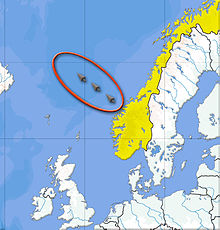
Storegga Slide
[3][4] In Scotland, traces of the subsequent tsunami have been recorded, with deposited sediment being discovered in Montrose Basin and the Firth of Forth up to 29 km (18 mi) inland and 4 m (13 ft) above current normal tide levels.
In this case, a trigger such as an earthquake could have caused a large area of seafloor to collapse into the deep Norwegian sea, thus carrying the enormous volume of accumulated sediment along with it.
[7] At, or shortly before, the time of the Second Storegga Slide, a land bridge known to archaeologists and geologists as Doggerland linked Britain, Denmark and the Netherlands across what is now the southern North Sea.
This area is believed to have included a coastline of lagoons, marshes, mudflats and beaches, and to have been a rich hunting, fowling and fishing ground populated by Mesolithic human cultures.
With present-day populations and sea levels, a similar event today could devastate and destroy seafront and port areas of Arbroath, Stonehaven, Aberdeen, Inverness, Wick, and Montrose.