Tropical Storm Colin (2010)
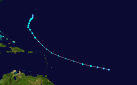
A broad area of low pressure resulted from the consolidation of the two waves on August 1, when it was situated about 750 mi (1,210 km) west-southwest of the Cape Verde Islands.
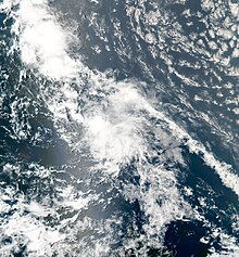
Over the course of the next 24 hours, shower and thunderstorm activity became increasingly consolidated with the low, but the system lacked a well-defined circulation to be considered a tropical cyclone at the time.
Thunderstorm activity became increasingly well defined, and it is estimated that the depression became Tropical Storm Colin at 0600 UTC on August 3 while centered 840 mi (1,350 km) east of the Lesser Antilles.
[1] As the remnants passed north of the northern Leeward Islands, a reconnaissance aircraft investigated the system on August 4, but no closed circulation was found.
A combination of microwave and satellite imagery during the morning hours of August 5 revealed the reformation of a closed low, and Colin's remnants regained tropical storm status at this time while located 280 mi (450 km) north-northeast of San Juan, Puerto Rico.
[1] Despite relatively unfavorable vertical wind shear impacting Colin, deep thunderstorm activity developed atop its center of circulation.
Data from a reconnaissance aircraft during the afternoon hours of August 5 revealed that the system reached a peak intensity with winds of 60 mph (97 km/h) and a minimum barometric pressure of 1,005 mbar (29.7 inHg).
Further weakening occurred over the next few hours as the cyclone's center of circulation became elongated, and Colin once again degenerated into a trough of low pressure at 1200 UTC while located approximately 100 mi (160 km) southwest of Bermuda.
[4] These values were later decreased after Colin weakened on August 6, with only a minimal storm surge forecast and rainfall roughly 1 in (25 mm) less than previously stated.
Tropical storm (39–73 mph, 63–118 km/h)
Category 1 (74–95 mph, 119–153 km/h)
Category 2 (96–110 mph, 154–177 km/h)
Category 3 (111–129 mph, 178–208 km/h)
Category 4 (130–156 mph, 209–251 km/h)
Category 5 (≥157 mph, ≥252 km/h)
Unknown