Tropical Storm Warren (1984)
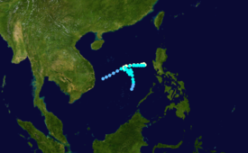
Warren moved north and later north-northwest but late on October 24, the storm began to meander in the South China Sea.
The precursor of Tropical Storm Warren was first noted on October 17 as a poorly organized area of convection over 550 km (340 mi) northeast of Mindanao Island.
Initially, synoptic data suggested that the storm's circulation was broad, ill-defined, and positioned over the monsoon trough.
The alert was cancelled less than 24 hours later, however, in response to a decrease in the storm's convection, as well as, strong wind shear and its close proximity to land.
[1] At 00:00 UTC on October 23, both the Joint Typhoon Warning Center (JTWC) and the Japan Meteorological Agency (JMA) started tracking the system.
[2][nb 1][4] The aforementioned circulation was at first exposed from the deep convection, but by 03:00 UTC on October 23, the storm had rapidly become better organized.
[5][nb 2] Also around this time, the Philippine Atmospheric, Geophysical and Astronomical Services Administration (PAGASA) started tracking the storm and assigned it with the local name Reming.
[5] Starting midday on October 26, Warren stalled out for the next 12 hours, only to drift east-northeast in response to the inflow to Typhoon Vanessa and a trough to its north.
[1] By October 29, Warren began to expand in size in response to a monsoonal surge of moisture into the South China Sea.
[8] At 00:00 UTC on October 29, the JTWC downgraded Warren into a tropical storm,[4] though the JMA would not follow suit until 36 hours later.
Late on November 1, the circulation had become less defined and increasingly difficult to locate, and the JTWC estimated that Warren dissipated the next day.
[13] Offshore Marinduque Island, strong waves generated by the storm sunk a 745 t (745,000 kg) vessel, Venus,[11] within three minutes.
[14] Officially, the ship consisted of 83 passengers and 42 crewmen when it left Laoang for Samar Island, even though the captain claimed that there were as many as 240 aboard.
Tropical storm (39–73 mph, 63–118 km/h)
Category 1 (74–95 mph, 119–153 km/h)
Category 2 (96–110 mph, 154–177 km/h)
Category 3 (111–129 mph, 178–208 km/h)
Category 4 (130–156 mph, 209–251 km/h)
Category 5 (≥157 mph, ≥252 km/h)
Unknown