Tursi
Tursi (Turse in Tursitano dialect;[4] Ancient Greek: Θυρσοί, romanized: Thursoí; Latin: Tursium) is an Italian comune of 4,712 inhabitants[3] in the province of Matera in Basilicata, elevated to a city by decree of the President of the Republic Carlo Azeglio Ciampi on May 4, 2006.
The stream crosses the town at an altitude of 190 meters above sea level and continues for about ten kilometers to the east, where it becomes a tributary of the river Sinni.
[14] The territory dates back to the ancient Cenozoic and is formed by marly rocks, a very friable sedimentary mass composed of clay and limestone, with an earthy appearance and yellow ochre color.
[24] In fact, in the papal bull drafted by Pope Alexander II in 1068 the town is mentioned under the toponym “Tower of Tursio.”[26] A century later, in 1154, the Arab geographer Muhammad al-Idrisi during the creation of the Tabula Rogeriana on behalf of Roger II of Sicily, in the text Kitab nuzhat al-mushtaq fi'khtiraq al-'afaq, known as the book of King Roger, points to the city under the toponym of Tursah.
[28] Later, around the 8th century BC, several colonies were founded on the Ionian coast by Greeks from Ionia, including Siris, Heraclea, Metaponto and Pandosia.
[41] Later, having overcome the initial religious and cultural differences with the native populations, the invaders around 850 conquered much of the Metapontine plain and decided to quarter themselves in dominant and strategic areas, to better control trade within the territory.
[41] The flourishing exchange made possible the development of small military garrisons (ribāṭ) into full-fledged residential quarters called rabatane, the most important of which still include those of Tursi, Tricarico and Pietrapertosa.
[42] In 890 the Byzantines reconquered the territories that once belonged to the Western Roman Empire and succeeded, during the Arab-Byzantine wars, in finally driving out the Arab influence from the Lucanian lands as well.
[50] The relocation of citizens from the Anglona settlement, at the behest of Queen Joanna I, led to a significant transformation of Tursi, which until then could only be traced back to the Rabatana fortress.
[55] This testimony brings to light the existence of a public office of the Universitas of Tursi, especially in charge of the security of the Rabatana emphasizing the clear separation not only physical but also political-institutional between the village and the rest of the inhabited area.
[56] In January 1735 King Charles III of Spain visited the lands along the Ionian coast, and the province of Basilicata then and until the Bourbon reform of 1816 comprised 117 municipalities and was divided into 4 subdivisions: Tursi, Maratea, Tricarico and Melfi.
[57] The Tursi apportionment included 30 towns, stretched from Montescaglioso to Ferrandina, to the borders of Calabria and from Terranova di Pollino to Gallicchio, and was the seat of the Royal Collector of Basilicata.
The sun symbolizes light and life, the two laurel branches glory and prevalence over Anglona, and the olive trees represent the wealth of the land.
[100] Many young people decide to seek work or to perfect their university studies outside the country's borders, and once they graduate they hardly find a labor market capable of absorbing specialized professional positions.
[104] Tursi's main linguistic differences are evidenced by a phonetic diversity due to the transformation of the a vowel into e within words and the s-termination of many others,[105] such as: vèv ala chès (I'm going home), quànn tòrns?
Among the major Tursitan dialect exponents are the poets Vincenzo Cristiano and Albino Pierro, the latter of whom was nominated several times for the Nobel Prize in Literature.
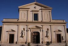
On the Sunday after Easter, however, the 18th-century statue depicting the Madonna is carried on the shoulders for a distance of more than 10 kilometers, from the sanctuary of Anglona to the Cathedral of the Annunziata in Tursi,[111] and on May 1 on the reverse route.
The less noble parts, such as pork rinds, lard, and innards were used in the preparation of frittole (cracklings) and nnuglia, which was called pezzente salami since it was made from meat scraps.
Other typical Tursitan dishes include: cicorjè e fèv – chicory and fava beans, finucch' e fasul – fennel and bean soup, mugnèm chièn – stuffed eggplant, pastùrej – stewed sheep, raskatelle ca' millica – homemade pasta (cavatelli) seasoned with tomato sauce and fried bread crumbs, snail soup, orange salad.
[41] In the following centuries, there would be a slight Byzantine and Norman influence in the castle and the new dwellings, which would force the township to expand toward the valley below, creating a clear distinction within the village.
[56] The first connection between the Rabatana and the rest of the village, strongly desired by Duke Carlo Doria, was a huge stone staircase, called petrizza and still in use today, built in 1594 that replaced the previous impervious mule track.
[124] The illustration made by De Silva outlines the view of Tursi from Mount San Martino at 324 m a.s.l., on the right bank of the Pescogrosso creek,[126] and shows how the nucleus developed in pre-Norman times due mainly to historical, morphological and demographic factors, centered around the castle according to a process of encastellation,[126] and expanded successively, especially between the 15th and 16th centuries without any planimetric regularity, but simply to crown the cathedral consolidating a modern forma urbis and gradually marginalizing itself from the historic core.
[127] The view predominantly captures the agricultural character of the city, as was the case for many Lucanian centers of the modern age,[128] specifically, Tursitan rurality is revealed in the distribution of the neighborhoods, among which citrus groves, vegetable gardens and fields for small-scale grazing open up.
[129] In this evolutionary context, towards the end of the sixteenth century, with the loss of the military functions that had qualified the Middle Ages and the gradual transformation of Tursi into a rural area, the ancient castle of pre-Norman layout became increasingly marginal to the town, which with its cylindrical towers at the corners of the ramparts, which had had a prominent function in the Aragonese period and in the viceregal period of the Kingdom of Naples, by the end of the seventeenth century now stands solitary on the natural sandstone cliff.
The ward contains the Cathedral of the Annunziata and the diocesan chancery building, which overlook Piazza Maria Santissima di Anglona, the current center of the city.
It arises at the foot of the hill on which the former convent of Saint Roch stands out, and takes its name from the location where it arose, slightly hilly, with an upward slope.
[133] The staccia orange is cultivated in the valley floor of the Agri and Sinni rivers and, even more specifically, in the municipalities of Tursi and Montalbano Jonico, but also in that of Colobraro, Valsinni and San Giorgio Lucano.
[138] Tursi's most visited structures remain historic buildings, such as the sanctuary of Santa Maria Regina di Anglona, elevated to a minor basilica in 1999, and the former Franciscan convent, both of which are national monuments.
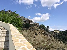
[139] Tursi's historic center, the Rabatana, experiences a particular influx of visitors in the summer months and especially during the Christmas season, when the district is used as a backdrop for a living nativity scene.
[147] Among the city's sports facilities, there is the stadium named after Pino Di Tommaso, the Stadio Mimmo Garofalo, which was inaugurated on June 3, 2007, by the Juventus under-16 students during the first match of the XI Gaetano Scirea Cup.