Willem River
Janszoon was captain of the Duyfken in 1605–1606, when part of the Gulf of Carpentaria was mapped, during the earliest documented visit to Australia by a vessel from Europe.
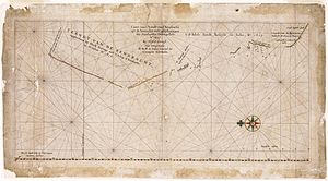
[1] The Willem River is located to the extreme left (north) end of the coastline on the chart and a closer view is provided below.
Other factors to back up that this is the Ashburton River is that it takes almost a 90 degree turn north-east once in the mouth as shown on the chart, and the northern headland of the river mouth in reality is of the same shape as shown on the chart.
[3][4][5][6] For example, between 1973 and 2008 the eastern spit at Entrance Point migrated eastwards by approximately 2.2 kilometres (1.4 mi).
Gerritsz., at the time cartographer in ordinary to the E.I.C., has "put together this chart of the Landt van d'Eendracht from the journals and drawings of the Steersmen", which means that he availed himself of authentic data [***].
He acquitted himself of the task to admiration, and has given a very lucid survey of the (accidental) discoveries made by the Dutch on the west-coast of Australia.
To the north it is found bounded by the "Willemsrivier", discovered in July 1618 by the ship Mauritius, commanded by Willem Janszoon [****].
On 31 July 1618, the Mauritius reached North West Cape (west of Exmouth Gulf), where crew members went ashore and saw footprints;[1] this was the closest that Europeans had yet come to making contact with indigenous Australians in Western Australia.