1934 Central America hurricane
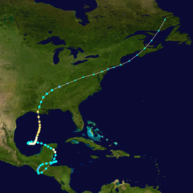
The storm struck the northeastern Yucatán Peninsula as a hurricane on June 9, crossing into the western Gulf of Mexico where its course made another loop.
Entire villages in El Salvador were destroyed by the floods, with damage extensive in the country's interior and along its Pacific coast.
The dam failed on June 7, and the resulting debris flow downstream destroyed most of Ocotepeque and killed an estimated 468 people.
The Yucatán Peninsula's sparse population mitigated significant damage when the hurricane struck Quintana Roo on June 9, though crops were impacted between Progreso and Payo Obispo.
The storm continued to produce high winds and flooding rainfall as it tracked northeast across the Mid-Atlantic states and into Canada, causing power outages and property damage.
The circumstances leading to the storm's formation in the western Caribbean Sea were unclear, marked only by inclement weather in the Gulf of Honduras.
[3] The following day, the cyclone made landfall near Belize City in the British Honduras with maximum sustained winds of 50 mph (80 km/h).
[4] Although interaction with land initially weakened the cyclone, the storm's winds quickly increased when it passed near Guatemala's Pacific coast.
[3] The storm continued towards the northeastern United States and the Canadian Maritimes, tracking across Nova Scotia and the northern shores of the Gulf of St. Lawrence before it was last documented on June 21 over Labrador.
[4][5] Between June 5–8, the center of the storm slowly tracked across British Honduras, southeastern Mexico, and Guatemala, with estimated peak sustained winds of 50 mph (80 km/h) along this path.
Lesser winds of 34 mph (55 km/h) were recorded in Belize City, British Honduras, where the storm initially made landfall.
[2] The slow-moving tropical cyclone produced torrential rainfall, resulting in widespread flooding that killed several thousand people.
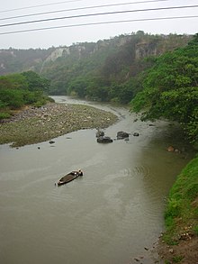
[12] Fourteen rivers throughout the country overflowed their banks, with floods along the Lempa proving to be particularly devastating in northwestern El Salvador.
[11] Power lines were brought down by the storm, with communications company All America Cables reporting an inability to connect with the country for 36 hours.
[2] Property damage totaled $2 million (1934 USD) and initial reports tallied 500 people rendered homeless near the city.
[8] A partially-completed stadium intended for the Central American and Caribbean Games in December 1934 was flooded, forcing to event to be delayed to March 1935.
[17] Long segments of the international railroad of Central America were washed out, requiring three months of repairs;[20][8] one train on its tracks derailed.
Low-lying areas of the capital city were flooded as the Río Grande quickly rose due to heavy rainfall.
On June 7, the barrier burst, producing a debris flow that killed an estimated 468 people, representing over 10 percent of Ocotepeque's population.
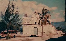
The church remains standing; all else is ruin, misery, mud...The Lempa and Ulúa rivers rose significantly due to the rainfall, with the latter rising 45 ft (14 m).
Residents of Pimienta fled to a hill to avoid advancing floodwaters only to be drowned there as the Ulúa River continued to rise.
[12] Honduran president Tiburcio Carías Andino appealed to American officials in Panama for tents due to the displacement of Ocotepeque residents.
[13] Six people were killed in the Mexican state of Chiapas following a plane crash, possibly due to strong winds from the storm.
[17] After completing its loop over Central America and reemerging into the Caribbean Sea, the storm made landfall as a Category 1 hurricane on Quintana Roo on June 9,[4] producing hurricane-force winds inland over the Yucatán Peninsula.
[34] Swells ahead of the storm flooded roads in low-lying areas of Brazos Island and cut off the beach at Playa Miramar.
[36] Northeast storm warnings were issued for the U.S. Gulf Coast between Pensacola, Florida, and Morgan City, Louisiana, on June 15.
[38] The hurricane moved ashore Louisiana at Category 2 intensity on June 16, passing over Jeanerette, west of Morgan City.
[37] The storms produced heavy rainfall across western parts of the state, elevating the Pearl River above flood stage by 1–3.5 ft (0.30–1.07 m) between Monticello and Jackson.
A 50 yd (46 m)-wide tornado struck a rural area north of Joelton, Tennessee on June 17, damaging a few farm buildings.
Tropical storm (39–73 mph, 63–118 km/h)
Category 1 (74–95 mph, 119–153 km/h)
Category 2 (96–110 mph, 154–177 km/h)
Category 3 (111–129 mph, 178–208 km/h)
Category 4 (130–156 mph, 209–251 km/h)
Category 5 (≥157 mph, ≥252 km/h)
Unknown