1940 Louisiana hurricane
Reports of a potentially destructive hurricane near the United States Gulf Coast forced thousands of residents in low-lying areas to evacuate prior to the storm moving inland.
Offshore, the hurricane generated rough seas and a strong storm surge, peaking at 6.4 ft (1.95 m) on the western edge of Lake Pontchartrain.
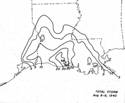
However, much of the property and crop damage wrought by the hurricane was due to the torrential rainfall it produced in low-lying areas, setting off record floods.
Rainfall peaked at 37.5 in (953 mm) in Miller Island off Louisiana, making it the wettest tropical cyclone in state history.
Nineteen official weather stations in both Texas and Louisiana recorded record-level 24-hour rainfall totals for the month of August as a result of the slow-moving hurricane.
[nb 1] In early August, an extratropical trough moved off the coast of South Carolina and Georgia, with a stationary front extending from it.
[1][2] A weak low-pressure area began to develop at the southern end of the front just offshore of Jacksonville, Florida.
[1] Initially, the storm had an open center of circulation and remained a frontal low as it moved southwestward across Florida, and thus was not considered a fully tropical system at the time.
[2] As a result, the storm was analyzed to have developed into a tropical depression off the western coast of Florida at 1200 UTC on August 3.
[3] At the time, weather reports revealed a definite cyclonic rotation, though the depression had a shallow minimum barometric pressure of 1012.5 mbar (hPa; 29.90 inHg).
[1] Moving west-southwest, the depression steadily intensified and attained tropical storm intensity at 0000 UTC on August 4.
[1] A minimum pressure of 995 mbar (hPa; 29.39 inHg) was analyzed for the system at 0600 UTC on August 5 based on an observation from a nearby ship.
Near Morgan City, Louisiana, 19 people went missing after going on a fishing trip;[5] they were later found marooned at Atchafalaya Basin.
Clise was abandoned during the storm 135 mi (215 km) south of the Mississippi River Delta, though its crew was also later rescued.
[15] Thirteen official weather stations in the state reported monthly 24-hour rainfall total records.
Impassable areas caused by rising floodwaters prevented firefighters from extinguishing a fire which burned down much of the Shell Oil Company's offices and supply warehouses in the town of Iowa.
Across the state, the hurricane caused $9 million in damages, though only six fatalities resulted, relatively less than most storms of similar scale.
The low death count was attributed to large evacuation procedures which underwent prior to the storm, as well as guidance provided from the newly opened Weather Bureau east of Lake Charles.
[12] In East Texas, where the hurricane made landfall late on August 7, strong winds were felt across the region.
[11] Property damage in Jefferson County, containing Port Arthur and nearby suburbs, was estimated at $1 million.
[18] A weather station near Sabine Pass recorded a similarly low pressure of 973 mbar (hPa; 28.74 inHg).

Tropical storm (39–73 mph, 63–118 km/h)
Category 1 (74–95 mph, 119–153 km/h)
Category 2 (96–110 mph, 154–177 km/h)
Category 3 (111–129 mph, 178–208 km/h)
Category 4 (130–156 mph, 209–251 km/h)
Category 5 (≥157 mph, ≥252 km/h)
Unknown