1945 Homestead hurricane
Thereafter, the hurricane began to weaken while moving across Florida, falling to Category 1 intensity only several hours after landfall late on September 15.
The system continued to weaken and transitioned into an extratropical cyclone near the border of North Carolina and Virginia early on September 18.
Most of the city of Homestead was destroyed, while at the Naval Air Station Richmond, a fire ignited during the storm burned down three hangars worth $3 million (1945 USD) each.
A station on the island observed a brief lull, along with a minimum barometric pressure of 28.83 inHg (976 mb), during the passage,[2] and nearby Clarence Town reported winds of 105 mph (169 km/h).
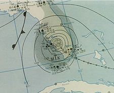
[5] At 13:00 UTC on September 15 reconnaissance aircraft entered the eye of the storm and registered a minimum central pressure of 28.29 inHg (958 mb).
[7] The eye of the cyclone passed very close to Homestead Air Reserve Base about an hour after landfall, where a central barometric pressure of 28.09 inHg (951 mb) was recorded, along with a nearly hour-long period of calm conditions.
[3] The observation suggested a landfall pressure of 949 mbar (28.0 inHg), and based on the storm's small size, sustained winds of about 130 mph (215 km/h), equivalent to a Category 4 on the current Saffir–Simpson scale.
Hurricane-force winds spread across much of Florida until the storm emerged into the western Atlantic near Ponte Vedra Beach early on September 17.
[5] After continuing through the southeast United States, the storm became extratropical near the border of North Carolina and Virginia midday on September 18.
[5] In advance of the storm, aircraft were evacuated from the Naval Air Station in Miami, Florida, where hundreds of airplanes left vulnerable locations.
[9] Military personnel sought shelter at Hialeah Race Track, while residents boarded homes and evacuated from coastal areas to public structures.
[11] Local officials from Cape Hatteras, North Carolina, to Brunswick, Georgia, ordered evacuations for coastal locations.
A number of sturdy structures that survived the 1926 and 1928 hurricanes collapsed; century-old trees were laid low and in some cases carried aloft.
After the storm, The Daily Gleaner, in Kingston, Jamaica, initiated a fund to offer aid for residents in the Turks and Caicos Islands.
[15] In Miami, gusts reached 107 mph (172 km/h), and damages were minimal, mostly snapped power lines, compared to communities in southern Dade County.
Another death was recorded after a schooner ran aground in present-day Bal Harbour, Florida, killing its chief engineer.
[11] The storm's most adverse impacts occurred in a 40-mile-wide (64 km) swath across southern Dade County, principally affecting the communities of Goulds, Redlands, South Miami, Perrine, Kendall, Princeton, Richmond, Homestead, and Florida City.
[21] Nearly 200 people were injured at the Naval Air Station (NAS) Richmond, when a fire ignited during the storm, affecting three large hangars worth $3 million each and destroying 150 automobiles, 366 airplanes, and 25 blimps;[17] losses at the base were greater than at any other single point in Florida as a result of the storm, owing mostly to the destruction of the hangars.
[22] Steel-framed doors at the NAS incurred structural deformation, which engineers deemed to be consistent with sustained winds of 125–130 mph (201–209 km/h)—an estimate later incorporated into a reanalysis of the storm.
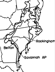
[12] In Charleston, South Carolina, strong winds caused high waves, but the storm arrived at low tide and produced modest damage.
[24] An estimated F2 tornado wrecked a logging camp at Gourdin, leaving mattresses in treetops, killing one person, injuring a few others, and causing $100,000 in losses.
A home, sited in Homestead, that was erected in the same year as the 1945 hurricane later registered the lowest pressure associated with Andrew to be measured on land in South Florida.

Tropical storm (39–73 mph, 63–118 km/h)
Category 1 (74–95 mph, 119–153 km/h)
Category 2 (96–110 mph, 154–177 km/h)
Category 3 (111–129 mph, 178–208 km/h)
Category 4 (130–156 mph, 209–251 km/h)
Category 5 (≥157 mph, ≥252 km/h)
Unknown