History of Somerset
There is evidence of human occupation since prehistoric times with hand axes and flint points from the Palaeolithic and Mesolithic eras, and a range of burial mounds, hill forts and other artefacts dating from the Neolithic, Bronze and Iron Ages.
The oldest dated human road work in Great Britain is the Sweet Track, constructed across the Somerset Levels with wooden planks in the 39th century BCE.
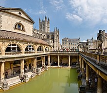
Following the Roman Empire's invasion of southern Britain, the mining of lead and silver in the Mendip Hills provided a basis for local industry and commerce.
There is evidence from flint artefacts in a quarry at Westbury that an ancestor of modern man, possibly Homo heidelbergensis, was present in the area from around 500,000 years ago.
[2] Other experts suggest that "many of the bone-rich Middle Pleistocene deposits belong to a single but climatically variable interglacial that succeeded the Cromerian, perhaps about 500,000 years ago.
"[3] Animal bones and artefacts unearthed in the 1980s at Westbury-sub-Mendip, in Somerset, have shown evidence of early human activity approximately 700,000 years ago.
The bones were defleshed and probably ritually buried though perhaps related to cannibalism being practised in the area at the time or making skull cups or storage containers.
[7] Somerset was one of the first areas of future England settled following the end of Younger Dryas phase of the last ice age c. 8000 BC.
[8] At the end of the last ice age the Bristol Channel was dry land, but later the sea level rose, particularly between 1220 and 900 BC and between 800 and 470 BCE, resulting in major coastal changes.
The Somerset Levels became flooded, but the dry points such as Glastonbury and Brent Knoll have a long history of settlement, and are known to have been occupied by Mesolithic hunters.
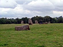
[9][10] The county has prehistoric burial mounds (such as Stoney Littleton Long Barrow), stone rows (such as the circles at Stanton Drew and Priddy) and settlement sites.
In the Neolithic period people started to manage animals and grow crops on farms cleared from the woodland, rather than act purely as hunter gatherers.
[20] There is evidence of mining on the Mendip Hills back into the late Bronze Age when there were technological changes in metal working indicated by the use of lead.
[24] The Roman invasion, and possibly the preceding period of involvement in the internal affairs of the south of England, was inspired in part by the potential of the Mendip Hills.
The majority were struck in the reigns of emperors Constantius II and Julian and derive from a range of mints including Arles and Lyons in France, Trier in Germany and Rome.
The religion of the people of Somerset in this period is thought to be Christian but it was isolated from Rome until after the Council of Hertford in 673 AD when Aldhelm was asked to write a letter to Geraint of Dumnonia and his bishops.
[43] The Saxons conquered Bath following the Battle of Deorham in 577, and the border was probably established along the line of the Wansdyke to the north of the Mendip Hills.
Then Cenwalh of Wessex broke through at Bradford-on-Avon in 652, and the Battle of Peonnum possibly at Penselwood in 658, advancing west through the Polden Hills to the River Parrett.
The Anglo-Saxon Chronicle reports that in January 878 the King Alfred the Great fled into the marshes of Somerset from the Viking's invasion and made a fort at Athelney.
Alfred established a series of forts and lookout posts linked by a military road, or Herepath, so his army could cover Viking movements at sea.
The Herepath has a characteristic form which is familiar on the Quantocks: a regulation 20 m wide track between avenues of trees growing from hedge laying embankments.
There was a royal palace at Cheddar, which was used at times in the 10th century to host the Witenagemot,[52] and there is likely to have been a "central place" at Somerton, Bath, Glastonbury and Frome since the kings visited them.
After the Norman Conquest, the county was divided into 700 fiefs, and large areas were owned by the crown,[53] with fortifications such as Dunster Castle used for control and defence.
[25] Farming seems to have prospered for the next three centuries but was severely hit by the Black Death which in 1348 arrived in Dorset and quickly spread through Somerset, causing widespread mortality, perhaps as much as 50% in places.
The wool was spun into thread on isolated farms and collected by merchants to be woven, fulled, dyed and finished in thriving towns such as Dunster.
The land started to be enclosed and from the 17th century onwards larger estates developed, leading to establishment of areas of large regular shaped fields.
The rebels landed at Lyme Regis and travelled north hoping to capture Bristol and Bath, puritan soldiers damaged the west front of Wells Cathedral, tore lead from the roof to make bullets, broke the windows, smashed the organ and the furnishings, and for a time stabled their horses in the nave.
[76] The Society of Friends established itself in Street in the mid-17th century, and among the close-knit group of Quaker families were the Clarks: Cyrus started a business in sheepskin rugs, later joined by his brother James, who introduced the production of woollen slippers and, later, boots and shoes.
[90] It obtained water supplies from two sources via the Somerset Levels: the artificial Huntspill River which was dug during the construction of the factory and also from the King's Sedgemoor Drain, which was widened at the same time.
[citation needed] In the late 19th century the boundaries of Somerset were slightly altered, but the main change came in 1974 when the county of Avon was set up.