South West Coast Path
[8] Following investment through the Rural Development Programme for England, more detailed research was undertaken in 2012, and this found the annual spend by walkers to have risen to £439 million which sustains 9771 full-time equivalent jobs.
[10] The South West Coast Path is no longer used by the Coastguard but it has been transformed from a practical defence system into a resource for recreational walkers.
The path is covered by England's right-of-way laws, as amended by the Countryside and Rights of Way Act 2000, which keep historic footpaths open to the public even when they pass through private property.
[23] The Exmoor Coastal Heaths have been recognised as a Site of Special Scientific Interest (SSSI) due to the diversity of species present.
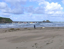
[29] After rounding Widmouth Head, the path passes 'The Coastguard Cottages' in Hele Bay and enters the seaside resort of Ilfracombe, with its small harbour, surrounded by cliffs.
A seasonal foot passenger ferry service runs from the harbour to Lundy Island, and the Balmoral, the Waverley and pleasure boats ply to Porthcawl near Swansea.
After crossing medieval Barnstaple Long Bridge, the path then turns west following the disused Bideford & Instow Railway line along southern bank of the Taw past Fremington Quay and the Fremington Quay Cliffs SSSI to Instow at the joint estuary of the Rivers Taw and Torridge and the Taw-Torridge Estuary (SSSI).
[35] The path then follows the coast around Clovelly Bay where several small villages including Abbotsham lie inland, because of the cliffs.
Hartland Point features a lighthouse and radar tower, and marks the western limit (on the English side) of the Bristol Channel with the Atlantic Ocean to the west.
The path crosses into Cornwall at Marsland Mouth and continues south-westwards along this rocky coast, past Morwenstow then Higher and Lower Sharpnose Points.
The Rumps, a dolerite intrusion, has Iron Age defences across its narrow neck[38] but the path heads straight past to Pentire Point then swings south-eastwards again into Polzeath.
The estuary of the River Camel forces a detour away from the sea to Rock and the Black Tor Ferry that takes walkers into Padstow.
A rail link with through trains to London and the North of England on summer weekends has helped the town prosper as a seaside resort which is visited by both surfers and clubbers.
After passing Nancekuke firing ranges, the path drops into Portreath, once a busy port serving inland tin mines around Redruth.
Although narrow, the estuary is tidal and fast flowing due to the large expanse of mud flats and docks that lie behind the Towans, so the path turns away from St Ives Bay to go round via Hayle.
Portheras Cove is a relief from the many small rocky bays along this coast but the cliffs then continue beyond the iconic, disused Crowns Mine at Botallack.
After passing Land's End the path continues further south past Pordenack Point and Nanjizal, also known as Mill Bay, before turning fully eastward at Gwennap Head.
Newlyn has a busy fishing harbour and is again favoured by artists, known as the Newlyn School;[49] it merges into Penzance and the path now follows the promenade through the town, passing Penzance railway station and continuing past the railway engine shed along the shore of Mount's Bay with its views of St Michael's Mount.
After passing The Lizard the path turns northwards, continuing past Housel Bay and a building used by Guglielmo Marconi for radio experiments,[51] then Bass Point with its Coastguard Station.
This natural haven is what made Falmouth such an important harbour, it being the last good shelter for ships heading westwards towards the Atlantic Ocean.
The next big headland is Dodman Point after which the coast path resumes its northwards course through Gorran Haven and the fishing harbour at Mevagissey to Pentewan where the once busy dock has silted up with sand.
This was the first harbour to serve the china clay industry around St Austell and has featured in several films as it is home to a heritage fleet of sailing ships.
[57] The path now passes Polridmouth (pronounced 'Pridmouth') and Readymoney Cove to enter Fowey ('Foy'), another busy harbour but this time the deep water quays are situated up river above the town.
The long beach of Whitsand Bay has a fast-rising tide and is a military firing range so the path runs inland behind Tregantle Fort to reach Freathy and Rame Head.
Beyond this lies Penlee Point and then the path turns northwards into Plymouth Sound, skirting Cawsand Bay and Mount Edgcumbe Country Park to reach the ferry at Cremyll.
From Wembury the path travels east into the South Hams district to the Warren Point Ferry, across the River Yealm, near Newton Ferrers.
The next 6 miles (10 km) of cliff top paths from Bolberry Down past Bolt Head and the tidal ria of Kingsbridge Estuary to Prawle Point, belong to the National Trust.
Kingswear is the terminus of the Dartmouth Steam Railway which follows the River Dart, but the coast path climbs out of the village in the opposite direction to reach Torbay, known as "The English Riviera".
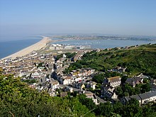
[64] Further east, where it shares its route with the Monarch's Way, the path passes through Charmouth, up Golden Cap (the highest point on the south coast),[65] and on through West Bay (near Bridport), to Burton Bradstock at the start of Chesil Beach, an 18-mile-long (29 km) tombolo.
The South West Coast Path, covering such a wide area, inevitably intersects with other, more local, routes, and it connects with many other long-distance paths offering opportunities for even longer expeditions: There are regular train services from other parts of the UK to the south west, principal destination stations being Barnstaple, Exeter, Newquay, Penzance, Plymouth and Weymouth.