Geography of Somerset
The Quantocks and the Blackdown Hills are Areas of Outstanding Natural Beauty, and the island of Steep Holm, in the Bristol Channel, is one of many Sites of Special Scientific Interest.
The county divides into four main geological regions, spanning the Silurian, the Devonian and the Carboniferous to the Permian, that influence the landscape.
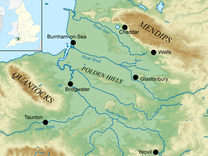
The Mendips run west to east between Frome and Weston-super-Mare, overlooking the Somerset Levels to the south and the Chew Valley and other tributaries of the River Avon to the north.
[2] The Mendips are composed of Carboniferous Limestone and water erosion has created gorges, dry valleys, screes, swallets and caves as well as various karst features.
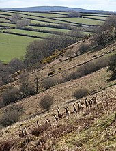
[3] The Quantocks extend northwards from the Vale of Taunton Deane, for about 15 mi (24 km) to the north-west, ending at Kilve and West Quantoxhead on the coast of the Bristol Channel.
The landscape consists of heathland with heather, gorse and bracken, ancient woodland and pasture land, with steep slopes and wooded combes.
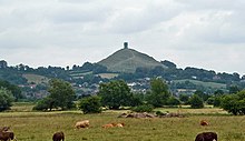
This part of the Levels has traditionally been known as Sedgemoor, and to the east is Glastonbury Tor, an isolated hill projecting from the low-lying plain.
[1] The north coast is gently shelving with low cliffs and long stretches of sandy beach, some sections of which, especially in the northwest, are muddy.
[1] The main rivers in Somerset rise in the hills and flow northwards and westwards into the Bristol Channel; these are the Axe, Brue, Parrett and its tributaries, and Exe.
It passes between Uphill Cliff and Brean Down and reaches the sea at Weston Bay; it forms the northern boundary of the county.
There is a raised bog in the central Brue valley and the surrounding area is a mosaic of swamps, meres and alder woodland.
[10] The Somerset Levels are liable to flooding and the only significant towns are Glastonbury and Street which occupy slightly elevated locations on the Polden Hills.
It is home to the United Kingdom Hydrographic Office and the regional headquarters of such organisations as Defra and the Charity Commission for England and Wales.
The town was dependent on the woollen industry, but is now associated with metal-working and printing, and large numbers of residents commute to Bristol and Bath.
They make up a sequence of lavas, tuffs (volcanic ash), shales and mudstones in a narrow outcrop to the northeast of Shepton Mallet in the eastern Mendip Hills.
[15] Rocks from the Devonian (419–359 million years ago) are found across much of Exmoor,[16] the Quantocks, and in the cores of the folded masses that form the Mendip Hills.
The limestones contain fossils of crinoids (sea-lilies), corals and brachiopods, providing evidence of the abundant marine life that existed in the shallow tropical seas that covered these areas at that time.
These landscapes are the limestone karst and lias of the north, the central clay vales and wetlands, the oolites of the east and south, and the Devonian sandstone of the west.
[21] In summer the Azores high pressure system affects the south-west of England, but convective cloud sometimes forms inland, reducing the number of hours of sunshine.
[21] Most rainfall in autumn and winter is caused by the arrival of Atlantic depressions, which bring moisture-laden air from the southwest and west.
In summer, a large proportion of the rainfall is caused by sunlight heating the ground, leading to convection and the formation of showers and thunderstorms.
[26] Many hillsides, such as at Cadbury Castle, Ham Hill and Maes Knoll, and sheltered valleys provided defensible locations for early human settlements.
The large tidal variation provided access inland, a key factor in distributing goods and produce, using rivers such as the Parrett and Avon.
[30][31] Somerset is a predominantly agricultural county with arable cropping and dairy farming; Cheddar cheese is a well-known product.
Large numbers of cattle and sheep are kept, and Exmoor ponies and red deer roam on the open moorland in the west of the county.
[33] The Somerset Levels between the ancient towns of Glastonbury and Wells have traditionally been used for growing withies, flexible, strong willow stems, used for many centuries for making furniture, baskets and fencing.
The western end of the Mendip Hills has, since 1972, been designated an Area of Outstanding Natural Beauty (AONB) under the National Parks and Access to the Countryside Act 1949.
[43] A large number of sea bird are resident or visit the island, particularly European herring gulls (Larus argentatus) and Lesser black-backed gulls (Larus fuscus),[44] but it is mainly preserved for its botanical interest; it is the only site in the United Kingdom where wild peonies grow.
It stretches from the coastline between the towns of Portishead and Clevedon, extending eastwards past Nailsea, around the Bristol conurbation, and through to the city of Bath.
The green belt border intersects with the Mendip Hills Area of Outstanding Natural Beauty (AONB) along its south boundary, and meets the Cotswolds AONB by its eastern extent along the Wiltshire county border, creating an extended area protected from inappropriate development.