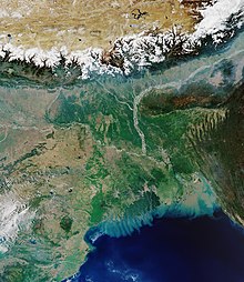
Indo-Gangetic Plain
As the region was formed by the deposits of the three major rivers–Indus, Ganges and Brahmaputra, the plains consists of the world's largest expanse of uninterrupted alluvium.
The region was home to the Indus Valley civilisation in 3000 BCE, which was one of the earliest human settlements in the Indian subcontinent.
[5][6] The fertile terrain facilitated the rise and expansion of various empires such as the Mauryas, Kushan, Guptas, all of whom had their demographic and political centers in the Indo-Gangetic plain.
[12] However, Shihabuddin defeated the Rajputs in the Second Battle of Tarain, which led to the rise of the Delhi Sultanate in the region in the 13th century CE.
The region was formed as a result of continuous deposition of silt by the major river systems of Indus, Ganges and Brahmaputra in the depression that existed between the Himalayas in the north and Deccan plateau in the south.
As per Darashaw Wadia, the depression was a furrow that originally existed since the formation of the plateau in the south and the mountains in the north.
Edward Suess had suggested that the depression was a large syncline that was formed when the southward advance of the Himalayas was blocked by the Indian landmass.
[23] Sydney Burrard opined that the region was a deep rift that existed in the earth's crust, which was subsequently filled with alluvium.
As the region was formed by the deposits of major rivers, the plains consists of the world's largest expanse of uninterrupted alluvium.
[23][25] The Indo-Gangetic Plain is divided into two drainage basins by the Delhi Ridge, which is a northern extension of the Aravalli Hills.
Due to its rich water resources and fertile alluvial soil, it is one of the world's most densely populated and intensely farmed areas.
[23][29][30] The eastern part of the plain receives heavy rainfall during the monsoon after the summer, which commonly results in floods and inundations.
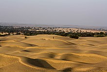
The rainfall decreases from the east towards the west with the western region encompassing drier areas such as the Thar desert.
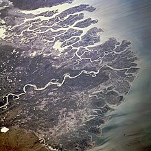
Most of the delta lies in the southern Sindh province of Pakistan with a small portion in the Kutch region of India.
The left quarter of the region is drained mainly by the tributaries of Indus–Ravi, Beas, and Sutlej and the Yamuna waters a small portion on the eastern border.
The in-between land which encompasses the city of Delhi, largely consists of no major streams except the seasonal Ghaggar River.
The region has a humid sub tropical climate with dry winters and receives the major part of rainfall during the south west monsoon between July and September.
The Ganges along with its tributaries such as the Yamuna, Gomti, Ghagara, Gandak, Chambal, Kosi, and Sone drain the region.
The Upper Ganga Plain stretches 149,000 km2 (58,000 sq mi) from the Shivalik range in the north and the Deccan Plateau in the south with the Yamuna River forming the rough western boundary.