Geography of California
The Sierra Nevada, the fertile farmlands of the Central Valley, and the arid Mojave Desert of the south are some of the geographic features of this U.S. state.
It is home to some of the world's most exceptional trees: the tallest (coast redwood), most massive (Giant Sequoia), and oldest (bristlecone pine).
The US Geological Survey defines the geographic center of California about 7.1 miles (11.4 km) driving distance from the United States Forest Service office in the community of North Fork.
Earth scientists typically divide the state into eleven geomorphic provinces with clearly defined boundaries.
From that point, 14 miles (23 km) south-southwest of Davis Dam on Lake Mohave, the southeast boundary follows the Colorado River to the international border west of Yuma, Arizona.
Northern California's economy is noted for being the de facto world leader in industries such as high technology (both software and semiconductor), as well as being known for clean power, biomedical, government, and finance.
The climate is characterized by moderately cold winters with heavy snowfall and warm, very dry summers with limited rainfall.
[3] As a consequence of the geology, the mountains have a unique flora, including several endemic or near-endemic species, such as Lawson's Cypress (Chamaecyparis lawsoniana) and Foxtail Pine (Pinus balfouriana).
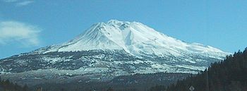
[4] The Cascade Range is a mountainous region stretching from the Fraser River in British Columbia, Canada down to south of Lassen Peak, California.
[11] The plateau supports large herds of mule deer (Odocoileus hemionus), Rocky Mountain Elk (Cervus canadensis), and pronghorn (Antilocapra americana).
The Basin and Range is a series of mountains and valleys (specifically horsts and grabens), caused by the extension of the Earth's crust.
In this province reside the White Mountains, which are home to the oldest living organism in the world, the bristlecone pine[16] To the west of the Central Valley lies the Coast Ranges, including the Diablo Range, just east of San Francisco, and the Santa Cruz Mountains, to the south of San Francisco.
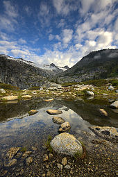
The highest peak in the contiguous United States, Mount Whitney at 14,505 feet (4.42 km), lies within the Sierra Nevada.
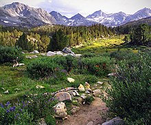
The Sierra has 200–250 sunny days each year, warm summers, fierce winters, and varied terrain, a rare combination of rugged variety and pleasant weather.
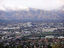
Where these cities are dense, with major downtown populations and significant rail and transit systems, much of Southern California is famous for its large, spread-out, suburban communities and use of automobiles and highways.
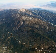
The Transverse Ranges include a series of east–west trending mountain ranges that extend from Point Conception, at the western tip of Santa Barbara County, eastward (and a bit south) to the east end of the San Jacinto Mountains in western Riverside County.
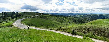
These Western boundaries are quite distinct, forming the dominant pie-slice shaped Antelope Valley in Southern California.
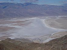
The Mojave Desert also contains the lowest, hottest place in the Americas: Death Valley, where temperature normally approaches 120 °F (49 °C), in late July and early August.
San Jacinto Peak's eastern shoulder has a cable tram that runs from the desert floor to nearly the top of the mountain where riders can set off hiking or go cross-country skiing.
The ground elevation is generally lower and in some areas was compressed downward, therefore the eastern Coachella and Imperial Valleys north of the U.S.-Mexican border are below sea level.
Owing to the long length of the state, Sea temperatures generally range from 50 °F (10 °C) in the northernmost parts during winter to 70 °F (21 °C) in the south coast during summer.
Therefore, sea life in and around California has examples of both Arctic and tropical, biotopes, leaning more towards the latter in the south coast and vice versa.
Before 1930, there was an extremely valuable sardine (herring) fishery off Monterey, but this was depleted, an event later famous as the background to John Steinbeck's Cannery Row.
[18] Waves from the Alaskan Good Friday earthquake of 1964 killed twelve people in Crescent City and caused damage as far south as Los Angeles.
It is expected, through the motions of plate tectonics that the sea floor spreading now acting in the Gulf of California (also known as the Sea of Cortez) will eventually extend through Southern California and along the San Andreas fault to below San Francisco, finally forming a long island in less than 150 million years.
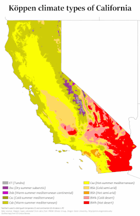
California's climate varies widely, from arid to subarctic, depending on latitude, elevation, and proximity to the coast.
Coastal and Southern parts of the state have a Subtropical Mediterranean climate, with somewhat rainy winters and dry summers.
The influence of the ocean generally moderates temperature extremes, creating warmer winters and substantially cooler summers, especially along the coastal areas.
Steep slopes and unstable soil make certain locations vulnerable to landslides in wet weather or during earthquakes.