Geography of Texas
Occupying about 7% of the total water and land area of the U.S.,[1] it is the second largest state after Alaska, and is the southernmost part of the Great Plains, which end in the south against the folded Sierra Madre Oriental of Mexico.
The longest straight-line distance is from the northwest corner of the panhandle to the Rio Grande river just below Brownsville, 801 miles (1,289 km).
[7] There are 3,700 named streams and 15 major river systems flowing through 191,000 miles (307,000 km) of Texas, supporting over 212 reservoirs.
Ranging from 20 to 58 inches (510 to 1,470 mm) of annual rainfall, this is a nearly level, drained plain dissected by streams and rivers flowing into coastal estuaries and marshes.
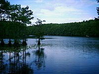
Windblown sands and dunes, grasslands, oak mottes and salt marshes make up the seaward areas.
[12] The North Central Plains are bounded by the Caprock Escarpment to the west, the Edwards Plateau to the south, and the Eastern Cross Timbers to the east.
[11] The largest concentration of playa lakes in the world (nearly 22,000) is on the Southern High Plains of Texas and Eastern New Mexico.
Highly expansive clays with characteristic dark coloration, called the Houston Black series, occur on about 1.5 million acres (6,000 km2) extending from north of Dallas south to San Antonio.
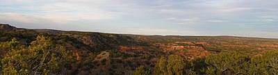
The Trans-Pecos region is the only part of Texas regarded as mountainous and includes seven named peaks in elevation greater than 8,000 feet (2,400 m).
[citation needed] This sequence is built atop the subsided crest of the Appalachian Mountains–Ouachita Mountains–Marathon Mountains zone of Pennsylvanian continental collision, which collapsed when rifting in Jurassic time opened the Gulf of Mexico.
West from this orogenic crest, which is buried beneath the Dallas–Waco–Austin–San Antonio trend, the sediments are Permian and Triassic in age.
A blanket of Miocene sediments known as the Ogallala formation in the western high plains region is an important aquifer.
With a large supply of natural resources, Texas is a major agricultural and industrial state, producing oil, cattle, sheep, and cotton.