River Brue
The River Brue originates in the parish of Brewham in Somerset, England, and reaches the sea some 50 kilometres (31 mi) west at Burnham-on-Sea.
The Brue Valley Living Landscape project commenced in January 2009 to restore and reconnect habitat that will support wildlife.
By the time it reaches Baltonsborough it is only some 10 metres (33 ft) above sea level and the surrounding countryside is drained into it by way of numerous rhynes.
It passes Glastonbury, where it acts as a natural boundary with nearby village of Street, before flowing in a largely artificial channel across the Somerset Levels and into the River Parrett at Burnham-on-Sea.
Its lower reaches are close to sea level, and the river above Bruton drains an area of 31 square kilometres (12 sq mi) into a steep and narrow valley.
Large areas of peat were laid down on the Somerset Levels, particularly in the River Brue Valley, during the Quaternary period after the ice sheets melted.
[10][11] The area is known to have been occupied since the Neolithic when people exploited the reedswamps for their natural resources and started to construct wooden trackways such as the Sweet and Post Tracks.
[12] The track was built between what was in the early 4th millennium BC an island at Westhay and a ridge of high ground at Shapwick, close to the River Brue.
The remains of similar tracks have been uncovered nearby, connecting settlements on the peat bog including the Honeygore, Abbotts Way, Bells, Bakers, Westhay and Nidons trackways.
[15] Discovered in 1892 by Arthur Bulleid,[16] it was inhabited by about 200 people living in 14 roundhouses,[14] and was built on a morass on an artificial foundation of timber filled with brushwood, bracken, rubble and clay.
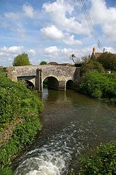
Pomparles Bridge stood at the western end of this lake, guarding Glastonbury from the south, and it is suggested that it was here that Sir Bedivere threw Excalibur into the waters after King Arthur fell at the Battle of Camlann.
[25] It then divided into two channels, one the Pilrow cut flowing north through Mark to join the Axe near Edingworth, and the other directly west to the sea at Highbridge.
(U.K.) c. lxxii) which enabled sections at Highbridge and Cripp's Bridge to be straightened, and new feeder channels such as the North and South Drains to be constructed.
[7] On 28 June 1917, 242.8 millimetres (9.56 in) of rain fell in 24 hours at Bruton,[31] leaving a water mark on one pub 20 feet (6.1 m) above the normal level of the river.
[35][36] The Glastonbury Canal used the course of the River Brue from Highbridge to Cripp's Bridge, and part of the South Drain to Ashcott Corner.
[40] Following summer floods of 1997 and the prolonged flooding of 1999–2000 the Parrett Catchment Project was formed, partly funded by the European Union Regional Development Fund, by 30 organisations, including British Waterways, Campaign to Protect Rural England, Countryside Agency, Department for Environment, Food and Rural Affairs, Environment Agency, Kings Sedgemoor and Cary Vale Internal Drainage Board (now part of Parrett Internal Drainage Board), Levels and Moors Partnership, National Farmers Union, Sedgemoor, Somerset County Council, South Somerset District Council, Taunton Deane and Wessex Water.
These include the conversion of arable land, adoption of the Sustainable Drainage Systems (SuDS) approach to controlling rainwater runoff from developed areas, dredging, raising riverbanks and improving pumping facilities.
It aims to help wildlife sustain itself in the face of climate change[57] while guaranteeing farmers and other landowners can continue to use their land profitably.
[58][59] The project covers an area of approximately 12,500 hectares (31,000 acres) encompassing the floodplain of the River Brue from a little east of Glastonbury to beyond the Catcott, Edington and Chilton Moors SSSI in the west.
There are 25 scheduled monuments and 746 Historic Environment Records in the project area including internationally important sites such at the Glastonbury Lake Village and Sweet Track.
[62] It is hoped to create larger and better connected patches of important habitats, in a way which also benefits the local economy and rural society.
One of the project's goals is to protect, restore and create areas of reedbed, grazing marsh, fen, raised bog, lowland meadow, purple moor grass and rush pastures and wet woodland.
Species of conservation concern (UK Biodiversity Action Plan priority species) that are likely to benefit from this project include plants such as: divided sedge (Carex divisa), English sticky eyebright (Euphrasia anglica), greater water parsnip (Sium latifolium), lesser butterfly orchid (Platanthera bifolia), marsh stitchwort (Stellaria palustris) and tubular water dropwort (Oenanthe fistulosa).
[68] Multiple bird species include Bewick's swan (Cygnus columbianus bewickii), Eurasian bittern (Botaurus stellaris), Eurasian bullfinch (Pyrrhula pyrrhula), *Eurasian wigeon (Anas penelope), European starling (Sturnus vulgaris), gadwall (Anas strepera), grasshopper warbler (Locustella naevia), hen harrier (Circus cyaneus), house sparrow (Passer domesticus), linnet (Carduelis cannabina), marsh harrier (Circus aeruginosus), marsh tit (Poecile palustris), merlin (Falco columbarius), northern lapwing (Vanellus vanellus), peregrine (Falco peregrinus), reed bunting (Emberiza schoeniclus), short-eared owl (Asio flammeus), skylark (Alauda arvensis), song thrush (Turdus philomelos), teal (Anas cracca), willow tit (Poecile montanus) and yellowhammer (Emberiza citrinella).
[70] Anglers will find pike in excess of 20 pounds (9.1 kg), with good stocks of chub, dace, roach, bream, tench, perch, rudd, and gudgeon.
There is further 2 miles (3.2 km)[76] walk or cycle westwards mainly alongside the River Brue, following the approximate flat path way of the former S&DJR extension route, takes the traveller into Burnham-on-Sea.