Hesperian
The Hesperian is a geologic system and time period on the planet Mars characterized by widespread volcanic activity and catastrophic flooding that carved immense outflow channels across the surface.
[7] Volcanic outgassing released large amounts of sulfur dioxide (SO2) and hydrogen sulfide (H2S) into the atmosphere, causing a transition in the style of weathering from dominantly phyllosilicate (clay) to sulfate mineralogy.
[10] As the planet cooled, groundwater stored in the upper crust (megaregolith) began to freeze, forming a thick cryosphere overlying a deeper zone of liquid water.
[11] Subsequent volcanic or tectonic activity occasionally fractured the cryosphere, releasing enormous quantities of deep groundwater to the surface and carving huge outflow channels.
The Hesperian System and Period is named after Hesperia Planum, a moderately cratered highland region northeast of the Hellas basin.
It is an inferred geologic unit (e.g., formation) representing a sheetlike, wedgelike, or tabular body of rock that underlies the surface.
[23] A system is bound above and below by strata with distinctly different characteristics (on Earth, usually index fossils) that indicate dramatic (often abrupt) changes in the dominant fauna or environmental conditions.
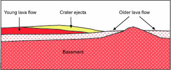
[4][21] The lower boundary of the Hesperian System is defined as the base of the ridged plains, which are typified by Hesperia Planum and cover about a third of the planet's surface.
[3] In eastern Hesperia Planum, the ridged plains overlie early to mid Noachian aged cratered plateau materials (pictured left).
It is generally interpreted to consist of reworked sediments originating from the Late Hesperian outflow channels and may be the remnant of an ocean that covered the northern lowland basins.
The series are based on referents or locations on the planet where surface units indicate a distinctive geological episode, recognizable in time by cratering age and stratigraphic position.
[31] The Hesperian was a time of declining rates of impact cratering, intense and widespread volcanic activity, and catastrophic flooding.
The weight of the immense Tharsis Bulge stressed the crust to produce a vast network of extensional fractures (fossae) and compressive deformational features (wrinkle ridges) throughout the western hemisphere.
Sulfuric-acid weathering at the surface produced an abundance of sulfate minerals that precipitated in evaporitic environments, which became widespread as the planet grew increasingly arid.
The Hesperian Period was also a time when the earliest evidence of glacial activity and ice-related processes appears in the Martian geologic record.
The lunar cratering record suggests that the rate of impacts in the inner Solar System during the Noachian (4000 million years ago) was 500 times higher than today.