Hurricane David
By the time the system dissipated on September 8, it had traversed the Leeward Islands, Greater Antilles, The Bahamas, the East Coast of the United States, and Atlantic Canada.
With winds of 175 mph (282 km/h), David was one of only 2 storms of Category 5 intensity to make landfall on the Dominican Republic in the 20th century, the other also being Inez, and the deadliest since the 1930 San Zenón hurricane, killing over 2,000 people in its path.
In addition, David was the deadliest tropical cyclone to hit the island of Dominica since the 1834 Padre Ruíz hurricane, which killed over 200 people.
[1] On August 25, the US National Hurricane Center reported that a tropical depression had developed within an area of disturbed weather, which was located about 870 mi (1,400 km) to the southeast of the Cape Verde Islands.
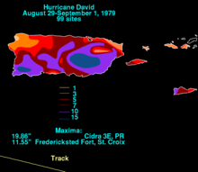
[3] David continued west-northwest, and intensified into a Category 5 hurricane in the northeast Caribbean Sea, reaching peak intensity with maximum sustained winds of 175 mph (282 km/h) and minimum central pressure of 924 mbar (27.3 inHg) on August 30.
David turned to the northwest along the western periphery of the subtropical ridge, and re-intensified to a Category 2 hurricane while over the Bahamas, where it caused heavy damage.
David continued to the north-northwest, and made its final landfall just south of Savannah, Georgia, as a minimal hurricane with 80 miles per hour (130 km/h) winds on September 5.
However, on August 29 a turn in the hours before moving through the area caused the 150 mph (240 km/h) hurricane to make a direct hit on the southern part of Dominica.
[5] Damage was greatest in the southwest portion of the island, especially in the capital city, Roseau, which resembled an air raid target after the storm's passage.
[5] In addition, David's winds uprooted many trees on the tops of mountains, leaving them bare and damaging the ecosystem by disrupting the water levels.
[3] One particularly deadly example of this was when a rampaging river in the mountainous village of Padre las Casas swept away a church and a school, killing several hundred people who were sheltering there.
[3] Upon making landfall, David brought a storm surge of only 2–4 ft (0.61–1.22 m), due to its lack of strengthening and the obtuse angle at which it hit.
[7] Two journalists from the Brevard County-based newspaper TODAY, reporter Dick Baumbach and photographer Scott Maclay, experienced extremely high winds as they followed the hurricane's progress from South Florida to Cocoa.
Storm surge and abnormally high tides caused significant erosion damage to State Road A1A in the vicinity of Sunrise Boulevard in Fort Lauderdale.
[7] Around 70,000 people in or near West Palm Beach lost electricity after falling trees downed around one-third of Florida Power & Light's main feeder lines.
[18] Abnormally high tides damaged docks and piers,[7] while also flooding portions of South Ocean Boulevard between Lake Worth and Lantana.
Heavy rains inundated portions of State Road 60 with up to 4 ft (1.2 m) of water between Interstate 95 and Yeehaw Junction because the St. Johns River marsh had difficulty draining.
The first twister severely impacted or destroyed about 50 mobile homes and a condominium complex in Melbourne Beach and a shopping center in Palm Bay after crossing the Indian River.
Overall, David was responsible for approximately $5 million in damage in Georgia, much of it in Chatham County, while two people drowned at Jekyll Island due to heavy surf.
Minutes later, a second tornado in the city demolished some fishing piers, substantial damaged several dwellings and a motels, and ignited a few fires, which destroyed a condominium complex.
High winds and rain downed power lines in the New York City area, leaving 2.5 million people without electricity during the storm's passage.
[27] In addition, the hurricane spawned numerous tornadoes while moving through the Mid-Atlantic and New England, with associated prominent wind damage occurring even in inland communities.
[28] In Virginia eight tornadoes formed across the southeastern portion of the state, of which six were F2's or greater on the Fujita scale, including two rated F3 in Fairfax County and Newport News.
Similar to the aftermath of other natural disasters, the distribution of the aid raised concerns and accusations over the amount of food and material, or lack thereof, for the affected citizens.
The crew provided work details and medical parties to offer assistance to the island and concentrated on the hospital buildings, the airstrip, and restoring power and water.
Businesses, non-governmental organizations, and volunteers within the Dominican Republic also contributed significantly, providing construction materials and bedding, clothing, and shoes.
[33] Cash donations and relief supplies were contributed from Red Cross agencies throughout the world, including from Australia, the Bahamas, Belgium, Canada, Chile, Colombia, Denmark, Finland, Germany, Honduras, Hungary, Italy, Japan, Monaco, New Zealand, Norway, Romania, Spain, Sweden, Switzerland, Thailand, the United Kingdom, the United States, and Yugoslavia.
Additionally France's Médecins Sans Frontières and Action d'urgence internationale and the United Kingdom's Oxfam also provided money and supplies.
Other national governments contributing aid included Argentina, Austria, Canada, Colombia, Cuba, El Salvador, France, Germany, Haiti, Japan, Liechtenstein, Netherlands, Norway, Sweden, Switzerland, Taiwan, the United Kingdom, and Venezuela.
[15] The hurricane also interrupted the filming of the movie Caddyshack that was taking place at the Rolling Hills Country Club in Fort Lauderdale.

Tropical storm (39–73 mph, 63–118 km/h)
Category 1 (74–95 mph, 119–153 km/h)
Category 2 (96–110 mph, 154–177 km/h)
Category 3 (111–129 mph, 178–208 km/h)
Category 4 (130–156 mph, 209–251 km/h)
Category 5 (≥157 mph, ≥252 km/h)
Unknown