Hurricane Erin (1995)
Erin then weakened slightly to a Category 1 hurricane while brushing the coast of the Florida Panhandle, before making landfall at Pensacola Beach later on August 3 with winds 85 mph (137 km/h).
Erin proceeded to move northeastward and then eastward across the interior of the Eastern United States, prior to merging with a frontal system in West Virginia on August 6.
The outer bands of Erin caused seven deaths in Jamaica, with five due to a plane crash and the other two after lightning struck two teenage boys.
[2] The storm steadily intensified while moving slowly west-northwestward and became a Category 1 hurricane near Rum Cay around 00:00 UTC on August 1,[1] after a reconnaissance aircraft flight observed flight-level winds of 99 mph (159 km/h) and satellite imagery noted a more well-defined system and hints of an eye developing.
[3] Thereafter, Erin accelerated somewhat from a forward speed of 6 to 17 mph (9.7 to 27.4 km/h) and then briefly jogged northwestward due to an upper-level low pressure area near Florida.
As a result, Erin was upgraded to a Category 2 hurricane in post-analysis and peaked with maximum sustained winds of 100 mph (160 km/h) and a minimum barometric pressure of 973 mbar (28.7 inHg).
The storm remained near the coast and weakened slightly before making landfall in Pensacola Beach, Florida, around 16:00 UTC on August 3 with winds of 85 mph (137 km/h).
The cyclone then turned northward close to the Mississippi River along the Arkansas–Tennessee state line early on August 5, before curving northeastward shortly thereafter and then eastward over southern Indiana and Ohio.
Computer servers became unable to handle the additional web traffic and data phone lines became tied up, causing the NHC to shut down the website on August 1.
[11] Many people on the east coast were wary of Erin due to recollections of the devastation wrought by Hurricane Andrew just three years earlier.
[9] Officials in the Florida Keys ordered the evacuation of residents living in mobile homes, with the Red Cross opening 17 shelters that could collectively house 15,285 people.
[17] Residents and some officials in the western Florida Panhandle may have been inadvertently lulled into a false perception of security due to the NHC projections showing the storm striking near Apalachee Bay, while advisories later on August 2 indicated a landfall in Mississippi.
Emergency workers sent evacuation notices to 2,003 residences of Pensacola Beach by pre-recorded phone messages just hours before Erin made landfall.
The plane, a Cessna 310 twin-engine aircraft owned by RegionAir, carried four employees of Brinks Jamaica, who were due to testify in a court hearing, and a pilot.
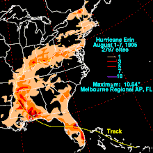
[39] In the Treasure Coast – Indian River, Martin, and St. Lucie counties – the storm produced sustained winds up to 86 mph (138 km/h) at the Sebastian Inlet.
[1] Despite being directly struck by the hurricane, the three-county region and the adjacent inland counties of Okeechobee and southern Osceola did not experience significant impact, with effects mainly limited to downed trees and signs and minor flooding.
[36] The worst impacts along the east coast of Florida occurred in Brevard County, where anemometers measured surface wind gusts up to 76 mph (122 km/h) at the Melbourne International Airport.
Heavy rainfall left several major and secondary roads impassable in Melbourne and Palm Bay,[44] including some lanes of Interstate 95.
A pump system failed after the electricity went out, causing raw sewage to flood a home beyond repairs in southwestern Orange County.
The first tornado toppled many trees on State Road A1A on southern Amelia Island, while the second twister partially deroofed a mall in Jacksonville Beach.
[54] Charlotte, DeSoto, Lee, and Manatee counties experienced little impact other than some residences losing power, falling trees, and minor street flooding.
[41] The hurricane caused minor to moderate damage to approximately 500 structures,[59] including 22 homes,[41] in southern Walton County, with lesser impact farther inland.
[61] At Okaloosa Island, storm tides washed away 50 ft (15 m) of the fishing pier, while winds severely damaged the roof of a hotel and shattered 18 glass wall panes at its dining area.
[41] In Santa Rosa County, the storm left Navarre Beach particularly hard hit, where nearly one-third of the buildings suffered major damage,[62] including the destruction of four condominiums under construction.
The gymnasium at Pace High School lost a large section of its roof and suffered water damage after rain entered the building.
Tropical storm force winds in the southwestern Alabama, including the Mobile metropolitan area, downed trees and power lines.
[74] Approximately 2 to 4 in (51 to 102 mm) of precipitation fell in portions of West Virginia, causing the Middle Island Creek to overflow, but little damage occurred as rainfall was beneficial otherwise.
[76] In Ohio, the remnants of Erin caused flash flooding after bringing additional rainfall to areas already saturated due to heavy precipitation thunderstorms in the previous few days.
Governor Chiles then requested a disaster declaration,[79] approved by President Bill Clinton for Bay, Brevard, Escambia, Okaloosa, Santa Rosa, and Walton counties.
[83] An aid package created by the Florida Legislature and approved by Governor Chiles on August 25 expended $8.8 million to the 20 hardest-hit counties to supplement federal disaster assistance.

Tropical storm (39–73 mph, 63–118 km/h)
Category 1 (74–95 mph, 119–153 km/h)
Category 2 (96–110 mph, 154–177 km/h)
Category 3 (111–129 mph, 178–208 km/h)
Category 4 (130–156 mph, 209–251 km/h)
Category 5 (≥157 mph, ≥252 km/h)
Unknown