Hurricane Fernanda (1993)
Instead, the hurricane slowed its forward motion and turned away from the state, although it still produced high waves along the eastern shore of the islands.
The system gradually organized as it continued westward, and on August 9, it developed into Tropical Depression Seven-E about 400 miles south of Manzanillo, Colima.
[1] Upon being classified, the National Hurricane Center (NHC) described the depression as "a large monsoon-like system", with abundant convection and well-defined upper-level outflow.
[1] By August 14, the eye had become less distinct as the storm moved over cooler waters, while winds decreased to below major hurricane status, or Category 3 intensity.
[5] By August 15, the storm was expected to pass between Maui and the Big Island of Hawaii; however, the CPHC noted uncertainty due to an approaching upper-level trough, which would produce a more northerly tack.
[1] Early on August 16, Hurricane Fernanda was expected to continue westward and bring hurricane-force winds to the Big Island of Hawaii.
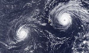
[7] Early on August 15, the Central Pacific Hurricane Center (CPHC) issued a tropical storm watch for the Big Island of Hawaii, meaning gale-force winds were possible within 36 hours; concurrently, a high surf advisory was put into effect for all eastward facing shorelines.
[8] Early the next day, the CPHC upgraded the watch to a hurricane warning for the Big Island of Hawaii, as Fernanda was expected to continue its westward track.
[9] When the hurricane slowed, its movement was uncertain, although all watches and warnings were canceled by August 17, when Fernanda began its northwest track.
[14] While moving slowly for a few days, Hurricane Fernanda produced high surf along the eastern shores of the Hawaiian Islands.

Tropical storm (39–73 mph, 63–118 km/h)
Category 1 (74–95 mph, 119–153 km/h)
Category 2 (96–110 mph, 154–177 km/h)
Category 3 (111–129 mph, 178–208 km/h)
Category 4 (130–156 mph, 209–251 km/h)
Category 5 (≥157 mph, ≥252 km/h)
Unknown