Hurricane Bud (2018)
Bud ultimately peaked the next morning with maximum sustained winds of 140 mph (230 km/h) and a minimum central pressure of 943 mbar (943 hPa; 27.8 inHg).
The remnants of Bud moved towards the Southwestern United States, bringing tropical moisture and gusty winds to the region.
Bud prompted the issuance of multiple watches and warnings for Baja California Sur and western and central Mexico.
Rains from Bud's remnants brought relief to drought-stricken areas and slowed the growth of wildfires in Wyoming and Colorado.
During the next week, the wave propagated westward, before moving over northern South America and entering the Eastern Pacific Ocean on June 6.
Over the next couple of days, atmospheric convection associated with the system significantly increased, before an area of low pressure developed on June 9.
Later that day, the National Hurricane Center (NHC) initiated advisories on the system, as it had developed into a tropical depression, while located about 330 mi (530 km) south of Acapulco, Mexico.
[1][4] Bud began a period of rapid intensification soon after, amid a favorable environment of very warm sea surface temperatures, high mid-level moisture, and low vertical wind shear.
[5][6] By 18:00 UTC on June 10, Bud had strengthened into a Category 1 hurricane as a sporadic eye feature began to emerge on visible satellite imagery.
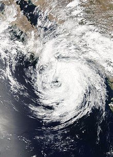
Bud reached its peak intensity as a Category 4 major hurricane, with maximum sustained winds of 140 mph (230 km/h) and a minimum central pressure of 943 mbar (27.85 inHg) at 00:00 UTC on June 12, while located 200 mi (320 km) southwest of Manzanillo, Mexico.
[10] Around midnight UTC on June 13, the hurricane turned towards the north-northwest as it moved around the southern edge of a mid-level high-pressure system.
[14] The mid- and low-level circulations of Bud split apart, with the former traveling quickly to the northeast and the latter over the Gulf of California and northwestern Mexico.
[15] The storm lost all of its thunderstorm activity and became a post-tropical cyclone around 12:00 UTC on June 15 while located about 140 mi (230 km) south-southwest of Huatabampito, Mexico.
The system continued to weaken and opened up into a trough of low-pressure by 00:00 UTC on June 16, about 35 mi (56 km) southwest of Huatabampito.
A tropical storm watch and warning were issued from Santa Fe to La Paz, Baja California Sur, on June 13.
Additional tropical storm watches were issued at 21:00 UTC on June 14 from La Paz to San Evaristo in Baja California Sur and Altata to Huatabampito along the Sonoran coast.
[21] Red alerts were issued in the State of Mexico for the Iztapalapa and Cuajimalpa districts due to the threat of torrential, flooding rainfall.
Small craft were to remain docked at ports in San Carlos, Baja California Sur; Manzanillo, Colima; Acapulco, Zihuatanejo, and Puerto Marqués, Guerrero;[23][24] and Mazatlán, Sinaloa.
[38] Cleaning operations commenced and one train was removed from the area a day after the flooding occurred; this allowed the station to resume normal traffic.
[39][48] State police and the Mexican Army set up temporary shelters in Tecpan de Galeana and La Unión for 100 people who were forced to evacuate due to heavy rainfall and high waves.
[34] Heavy rainfall from Bud caused the waters of the Laguna Negra of Puerto Marques to become contaminated with sewage, which in turn sparked a die-off of at least four fish species.
[44] Businessmen in the resort town of Pie de la Cuesta requested that Fonden, the National Disaster Relief Fund, be activated due to the damage sustained as a result of the storm.
[42] Bud damaged at least 78 businesses along the Jardin, Eréndira, Chuquiapan, Playa Azul, Las Peñas and Caleta beaches in Michoacan.
[51] At least 20 palapas, which are open-sided dwellings with thatched roofs made of dried palm leaves, were destroyed at the Jardin and Eréndira beaches.
[54][55] Restaurants located on the beach and homes in Aquila Municipality sustained damage after water from the ocean came 115 ft (35 m) inland.
[60][61] In Mexico City, the Collective Transportation System Metro halted service to several stations on its A-Line after roads flooded.
The storm caused multiple landslides and flooding on a highway connecting La Paz and Cabo San Lucas.
[65] The remnants of Bud sent a plume of moisture into the Southwestern United States, bringing much-needed rainfall to the drought-stricken region.
[16] Around 2 in (51 mm) of rain fell near Cave Creek, Arizona, generating streams of water that crossed over and blocked roadways.
[66] Thunderstorms generated by Bud's remnants produced wind gusts up to 61 mph (98 km/h) at the Taos Regional Airport in New Mexico.

Tropical storm (39–73 mph, 63–118 km/h)
Category 1 (74–95 mph, 119–153 km/h)
Category 2 (96–110 mph, 154–177 km/h)
Category 3 (111–129 mph, 178–208 km/h)
Category 4 (130–156 mph, 209–251 km/h)
Category 5 (≥157 mph, ≥252 km/h)
Unknown