Hurricane Javier (2004)
Hurricane Javier was a powerful tropical cyclone whose remnants brought above-average rainfall totals across the western United States in September 2004.
The wave crossed Central America on September 9 as convection steadily increased, and development of thunderstorm activity continued as it entered the East Pacific basin.
[1] Despite featuring limited outflow owing to modest easterly wind shear,[2] the system acquired sufficient organization to be deemed a tropical depression around 18:00 UTC on September 10.
[1] As the storm's convective appearance continued to mature, including the development of an eye and a rainband wrapping throughout the northwestern semicircle,[4] it strengthened into a hurricane around 18:00 UTC on September 12.
Javier continued to experience light northeasterly wind shear as it had since the system originally formed, resultant from an upper-level anticyclone focused over the Gulf of California.
[1] Early on September 14, Javier's small eye became cloud filled, and imagery of the system's internal structure suggested it was undergoing an eyewall replacement cycle.
By that time, the storm was entering cooler sea surface temperatures and strong southwesterly wind shear,[1] and those inhibitors were exacerbated by plentiful mid- to upper-level dry air near the cyclone.
The National Hurricane Center, predicted that Javier will parallel the Baja California coastline according to their forecast models and recurve as a weak storm and dissipate over the Southwestern United States.
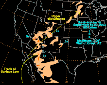
In Arizona, the remnants of Javier dropped widespread, light to moderate rainfall, improving topsoil moisture and greatly affecting a prolonged drought in the Southwestern United States.
Lightning and rain from Javier delayed the University of Arizona Wildcats football game against the Wisconsin Badgers for 88 minutes late in the second quarter, and flooding closed several roads.

Tropical storm (39–73 mph, 63–118 km/h)
Category 1 (74–95 mph, 119–153 km/h)
Category 2 (96–110 mph, 154–177 km/h)
Category 3 (111–129 mph, 178–208 km/h)
Category 4 (130–156 mph, 209–251 km/h)
Category 5 (≥157 mph, ≥252 km/h)
Unknown