Hurricane Madeline (1976)
When it began to recurve towards Mexico on October 6, the cyclone rapidly intensified and eventually made landfall at peak intensity as a Category 4.
Early on September 27, 1976, the Eastern Pacific Hurricane Center (EPHC) reported that a tropical disturbance had formed about 770 km (480 mi) to the southwest of San Jose, Costa Rica.
By the morning of September 29, the disturbance was upgraded to a 40 mph (65 km/h) tropical storm and based on ship reports and satellite imagery.
At that time, the EPHC reported that the circulation center was no longer visible and downgraded the system to a remnant low, while located 575 mi (925 km) to the southeast of Acapulco, Mexico.
[1] Over the following days, the low moved towards the west and started to regenerate with a circulation center becoming visible early on October 3.
[1] As the cyclone moved over an area of warm seas surface temperatures, the storm started to intensify.
Later that morning Madeline made landfall to the northwest of Zihuatanejo as a powerful Category 4 hurricane, before it rapidly dissipated over land.
[1][2] Mexican army headquarters put in effect an emergency plan three days prior to the arrival of the hurricane.
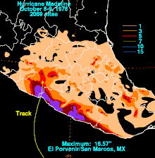
[12] Hurricane Madeline produced heavy rains over Mexico, peaking at 16.57 in (421 mm), rainfall fell at El Povenir/San Marcos.

Tropical storm (39–73 mph, 63–118 km/h)
Category 1 (74–95 mph, 119–153 km/h)
Category 2 (96–110 mph, 154–177 km/h)
Category 3 (111–129 mph, 178–208 km/h)
Category 4 (130–156 mph, 209–251 km/h)
Category 5 (≥157 mph, ≥252 km/h)
Unknown