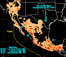
Hurricane Nora (1997)
The September storm formed off the Pacific coast of Mexico, and aided by waters warmed by the 1997–98 El Niño event, eventually peaked at Category 4 intensity on the Saffir–Simpson hurricane scale.
The storm was blamed for two direct casualties in Mexico, as well as substantial beach erosion on the Mexican coast, flash flooding in Baja California, and record precipitation in Arizona.
Nora impacted the majority of Mexico's Pacific-facing coasts including the states of Baja California, Colima, Guerrero, Jalisco, Michoacán, Nayarit, Oaxaca, Sinaloa and Sonora.
[1][2] After entering the Pacific Ocean, the wave encountered a favorable environment for tropical cyclogenesis, with very warm waters of around 29–30 °C (84–86 °F) and relatively light vertical wind shear.
[3][4] As a result, the system became better organized and developed a closed circulation, before the United States National Hurricane Center (NHC) initiated advisories and designated the disturbance as Tropical Depression Sixteen-E during 16 September.
[9] During that day, a large and ragged banding type eye appeared on satellite imagery, which shrank as the system intensified into a Category 2 hurricane with 1-minute sustained wind speeds of 105 miles per hour (165 km/h).
[3][13] During 20 September, Nora started to drift north-northwestwards along a ridge of high pressure, into an area of very warm sea-surface temperatures parallel to Mexico's western coast.
[4][20][21] As a result, the system was classified as a Category 1 hurricane at around 04:00 Pacific Standard Time (12:00 UTC) on 23 September, while it was located about 285 km (175 mi) to the southwest of Cabo San Lucas on the Baja California peninsula.
[3][4][24] The system subsequently moved over water in the vincinty of the Sebastián Vizcaíno Bay, before it made landfall at about 03:00 PST (11:00 UTC) to the south-southeast of San Fernando in Baja California as a Category 1 hurricane.
[3][18][24] As Nora moved northwards over the peninsula, atmospheric convection became less organized and the eye disappeared from infrared imagery, which caused the NHC to presume that it had weakened into a tropical storm.
[8][25] Later that day, Nora emerged into the northern Gulf of California and skirted the western coast as it moved northwards, before it made its final landfall near the mouth of the Colorado river to the west of Puerto Penasco, Sonora.
[1][2][25] After the system had made its final landfall, Nora continued to move northwards and at around 13:00 PST (21:00 UTC) on 25 September, it entered the United States of America near the border of Arizona and California.
[8][29] Nora's upper-level circulation did not have enough time to wind down and persisted for another couple of days before it dissipated on 28 September, after it had moved through portions of Utah, Colorado, Idaho and Wyoming.
[31] The system impacted the majority of Mexico's Pacific coast with effects reported in Baja California, Colima, Guerrero, Jalisco, Michoacán, Nayarit, Oaxaca, Sinaloa and Sonora.
[6][32] Later that day, the SMN issued a tropical storm warning for the area between Lázaro Cárdenas, Michoacán and Puntá Maldonado, Guerrero, in addition to the hurricane watch, because of the close proximity of the system to the coast.
[38] Offshore, the strong swells generated by the hurricane caused widespread loss of growing sea lettuce (Ulva lactuca), exacerbating the negative biological effects of the 1997–98 El Niño event.
[3] During the following day, the Mexican Government issued a hurricane warning between Bahia Balleno and Puerto Santo Tomás on the Pacific coast and from Santa Rosalía northwards on the Gulf of California side.
[52] The death of a diver who had been harvesting sea urchins of the San Quintin Valley and had died of Nitrogen narcosis, was partially attributed by Mexican authorities to strong underwater currents created by Nora.
[56] Authorities in the towns of Puerto Peñasco, San Luis Río Colorado and Plutarco Elías Calles canceled schools and advised residents to stay home and avoid driving.
[58] During 25 September, tropical storm force winds of up to 75 mph (120 km/h) were reported in the town, which caused trees to fall on power lines and prompted local officials to turn off the electric supplies.
[3] It also prompted the Phoenix, Arizona Weather Forecast Office to issue a test hurricane local statement in order to determine the availability of the product to their family of services.
[30] This caused several places to record their first significant rainfall since April 1997, while 0.27 in (6.9 mm) of rain fell on Los Angeles which ended a record-setting dry spell that had lasted since 18 February.
Several highways in the Coachella and Borrego Valleys to be closed due to flooding, while hundreds of automobile accidents caused traffic jams throughout San Diego and Orange Counties.
[1][81] These winds tore off shingles and awnings from houses, while street signs, traffic lights and powerlines were blown away which in turn caused about 10 000 people to lose power in Yuma.
[94] Within the state, it was feared that heavy rain would cause flash flooding and that streams and rivers, would suddenly and unexpectedly rise if tropical moisture associated with Nora impacted the area.
[95] As a result, flash flood watches and warnings were issued for Southern Utah during 25 September, while emergency services in Kane and Washington Counties provided sandbags to fire departments which were subsequently handed out for free to residents.
[94][95][96] Nora's remnant upper-level circulation moved into Utah during 25 September, where it produced a period of near hurricane-force winds that were observed at the Blowhard Mountain radar site, near Cedar City.
[30][29] Access to some outlying homes in Pahrump was cut-off as dirt roads became flooded and impassable, while several people were forced to stay at a shelter set up by the American Red Cross.
The National Transportation Safety Board later determined that the pilot's decision to fly into adverse weather and failure to maintain sufficient clearance above the mountainous terrain led to the crash of the plane into the side of a ridge rising roughly 3,000 ft (910 m) above mean sea level.
[105] There were no impacts reported in New Mexico from Nora after the system had moved more west than forecast, however, it left twice the normal amount of moisture in the air over the four-corners area which eventually condensed into rain-producing clouds.

Tropical storm (39–73 mph, 63–118 km/h)
Category 1 (74–95 mph, 119–153 km/h)
Category 2 (96–110 mph, 154–177 km/h)
Category 3 (111–129 mph, 178–208 km/h)
Category 4 (130–156 mph, 209–251 km/h)
Category 5 (≥157 mph, ≥252 km/h)
Unknown