Kalmyks
[8][9] The Oirat language belongs to the western branch of the Mongolic language family, whose speakers include numerous sub-ethnic groups (Derbet, Torgut, Khoshut, Olot, Dzungar (Zunghar), Bayad, Zakhchin, Khoton, Myangad, Buzava) across a wide geographical area of Uvs and Khovd provinces (aimags) of Western Mongolia (N = 209,412), and in Xinjiang Uygur Autonomous Region, China (N = 194,891).
[12] The contemporary Kalmyks are a branch of the Mongolian Oirats, whose ancient grazing-lands spanned present-day parts of Kazakhstan, Russia, Mongolia and China.
He wrote that the Torghuts owed their name either to the memory of the guard of Genghis Khan or, as descendants of the Keraites, to the old garde de jour.
Until the mid-17th century, when bestowal of the title of Khan was transferred to the Dalai Lama, all Mongol tribes recognized this claim and the political prestige attached to it.
As pastoralist nomads, the Oirats were organized at the tribal level, where each tribe was ruled by a noyon or prince who also functioned as the chief taishi "chieftain".
The deadlock ended during the reign of Batmunkh Dayan Khan, a five-year-old boy in whose name the loyal Eastern Mongol forces rallied.
The Torghuts became the westernmost Oirat tribe, encamped in the Tarbagatai Mountains region and along the northern stretches of the Irtysh, Ishim and Tobol Rivers.
Further west, the Kazakhs – a Turco-Mongol people – prevented the Torghuts from sending its trading caravans to the Muslim towns and villages located along the Syr Darya river.
The Khoshut, by contrast, were the easternmost Oirat, encamped near the Lake Zaysan area and the Semey region along the lower portions of the Irtysh River, where they built several steppe monasteries.
Some scholars, however, believe that the Torghuts sought uncontested pastures as their territory was being encroached upon by the Russians from the north, the Kazakhs from the south and the Dzungars from the east.
Large groups of Nogais fled southeast to the northern Caucasian plain and west to the Black Sea steppe, lands claimed by the Crimean Khanate, itself a vassal or ally of the Ottoman Empire.
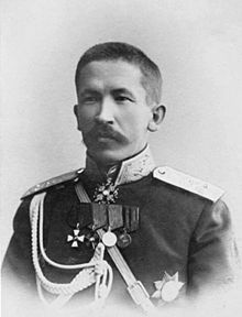
Ayuka Khan also waged wars against the Kazakhs, subjugated the Turkmens of the Mangyshlak Peninsula, and made multiple expeditions against the highlanders of the North Caucasus.
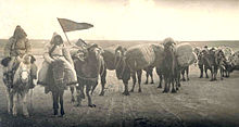
Routine contacts consisted in the main of seasonal commodity exchanges of Kalmyk livestock and the products thereof for such nomad necessities as brick tea, grain, textiles and metal articles, at Astrakhan, Tsaritsyn and Saratov.
[29] In January 1771 the oppression of Tsarist administration forced the larger part of Kalmyks (33 thousand households, or approximately 170,000–200,000 people) to migrate to Dzungaria.
After consulting the astrological chart, he set a return date, but at the moment of departure, the weakening of the ice on the Volga River permitted only those Kalmyks (about 200,000 people) on the eastern bank to leave.
Initially, this army was composed primarily of volunteers and Tsarist supporters but were later joined by the Cossacks, including Don Kalmyks, many of whom resisted the Bolshevik policy of decossackization.
Williamson of the British Military Mission to the Don Cossacks as follows: We could still hear scattered rifle fire and the sound of naval guns, and the Bolshevik sympathisers were sniping from the rooftops.
Some of the Kalmuk Cossacks still had their horses and the little tented carts in which they had travelled, and in the water all sorts of rubbish floated – trunks, clothes, furniture, even corpses.
The resulting upheaval caused many young Kalmyks to leave Kalmykia, especially in the rural areas, for economic opportunities in and outside the Russian Federation.
The Kalmyk authorities claimed that under the terms of the 1991 law On the Rehabilitation of Repressed Peoples, the lands, currently in the Astrakhan Oblast and Dagestan, would formally belong to Kalmykia with effect from July 1, 1993.
[59] Russian written sources mentioned the name "Kolmak Tatars" as early as 1530, and cartographer Sebastian Muenster (1488–1552) circumscribed the territory of the "Kalmuchi" on a map in his Cosmographia, which was published in 1544.
After the collapse of the Soviet Union, a large number of Kalmyks, primarily the young, moved from Kalmykia to larger cities in Russia, such as Moscow and St. Petersburg, and to the United States.
Further, remains of Buddhist monasteries have been found at Ablaiket near Ust Kamenogorsk and at Talgar, near Almaty, and at Sumbe in the Narynkol region, bordering China.
As a matter of policy, the Tsarist government and the Russian Orthodox Church sought to gradually absorb and convert any subject of another creed or nationality.
[70]: 39 Later on, the Tsarist government policy of encouraging Russian and German settlements along the Volga indirectly pressured Kalmyks to convert for economic reasons.
[72] This policy resulted in the suspension of Lamaist canonical regulations governing monastery construction and in Kalmyk temples resembling Russian Orthodox churches.
[citation needed] Other policies the Tsarist government implemented after the abolition of the Kalmyk Khanate in 1771, sought to gradually weaken the influence of the lamas.
Further, the economic crises that resulted from settler encroachment forced many monasteries and temples to close and lamas to adopt a secularized lifestyle.
Dr. Loewenthal writes that the policies were so enforced that the Kalmyk clergy and Buddhism were not mentioned in the work by B. Dzhimbinov, "Sovetskaya Kalmykiya," published in 1940.
The government of the Republic of Kalmykia sought to build a magnificent temple of a monumental scale in hopes of creating an international learning center for Buddhist scholars and students from all over the world.