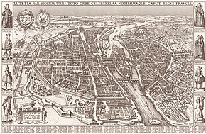
Pictorial map
They can feature all sorts of varied topics like historical events, legendary figures or local agricultural products and cover anything from an entire continent to a college campus.
With an emphasis on objects and style,[3] these maps cover an artistic spectrum from childlike caricature to spectacular landscape graphic, with the better ones being attractive, informative and highly accurate.
When printing came around, pictorial maps evolved into some of the earliest forms of advertising as cities competed amongst themselves to attract larger shares of the known world's commerce.
Later, during the Age of Exploration, maps became progressively more accurate for navigation needs and were often sprinkled with sketches and drawings such as sailing ships showing the direction of trade winds, little trees and mounds to represent forests and mountains and, of course, plenty of sea creatures and exotic natives, much of them imaginary.
As the need for geographical accuracy increased, these illustrations gradually slipped off the map and onto the borders and eventually disappeared altogether in the wake of modern scientific cartography.
The leading panoramic map artists in the U.S.A. were Herman Brosius, Camille N. Drie, Thaddeus Mortimer Fowler, Paul Giraud, Augustus Koch, D. D. Morse, Henry Welge, and A. L.
[4][5] Sometimes artistic exaggeration bordered on the fraudulent, as some travelers were drawn by images of idyllic, bustling towns with humming factories only to find a sad little bunch of mud-soaked shacks when they got there.
Many of these maps were commissioned by commercial entities (banks, oil companies, &c.), and in many cases the artists (often draftsmen working for architecture firms) are not attributed.