Tropical Storm Barry (2013)
The newly named Barry attained peak winds of 45 mph (75 km/h) before making landfall in Veracruz, Mexico on June 20.
[1] During the evening hours of June 15, the National Hurricane Center (NHC) began monitoring a large area of disturbed weather in association with a tropical wave over the southwestern Caribbean Sea.
[1] Drifting west-northwest, environmental conditions were expected to be favorable for organization,[3] but the system moved over eastern Nicaragua on June 16.
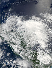
Despite moving over land, the circulation and convection became better organized, and after it emerged over open waters, the system developed into Tropical Depression Two at 1200 UTC on June 17 about 25 mi (45 km) north-northwest of La Ceiba, Honduras.
[1] Located about 60 mi (95 km) east of Monkey River Town, Belize,[4] the depression was not expected to undergo significant strengthening.
[5] Failing to intensify, the depression made landfall in southern Belize near Big Creek late on June 17 with winds estimated at 35 mph (55 km/h).
[9] A Hurricane Hunter reconnaissance mission into the depression during the afternoon of June 19 revealed gale-force winds, prompting the NHC to upgrade and name the system Tropical Storm Barry.
[1] The precursor to Barry produced significant rains in Nicaragua, causing flooding in 14 districts in the North Caribbean Coast Autonomous Region.
[14] Heavy rains in Honduras, peaking at 4 in (100 mm) in La Ceiba,[15] resulted in floods that damaged 60 homes and affected 300 people.
[25] Heavy rains in Veracruz, peaking at 14.6 in (370 mm) in Misantla,[26] brought more than a dozen rivers to critical levels and triggered flash floods that killed two people.

Tropical storm (39–73 mph, 63–118 km/h)
Category 1 (74–95 mph, 119–153 km/h)
Category 2 (96–110 mph, 154–177 km/h)
Category 3 (111–129 mph, 178–208 km/h)
Category 4 (130–156 mph, 209–251 km/h)
Category 5 (≥157 mph, ≥252 km/h)
Unknown