Tropical Storm Harvey (2011)
Additional organization occurred and Harvey attained its peak intensity of 65 mph (100 km/h) prior to coming ashore Belize on August 20.
The precursor disturbance caused thunderstorms throughout the Lesser Antilles, producing squally weather and gusty winds.
On Saint Croix in the United States Virgin Islands, gusty winds downed trees, which struck power lines, leaving minor electrical outages.
In response, the National Hurricane Center (NHC) noted the potential for the wave to develop into a tropical cyclone.
[3] The wave continued westward at 15 to 20 mph (24 to 32 km/h)[4] and became less vigorous over the next several days, with no strong convection present on August 13.
[7] The wave moved westward through the Caribbean Sea and produced areas of heavy showers and thunderstorms, although convection on the northern side of the system was limited, possibly a result of excessive Saharan dust.
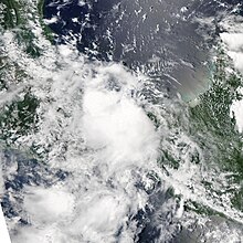
[11] After a low-level circulation became identifiable, the system was designated as Tropical Depression Eight at 1800 UTC on August 18,[1] while located about 100 mi (160 km) east-northeast of Cape Gracias a Dios.
[1] Harvey continued to strengthen throughout the afternoon, with an improved appearance on visible satellite imagery and good outflow across the northwestern part of the storm.
[14] A discussion by the NHC early on August 20 indicated the potential for Harvey to strengthen into a hurricane prior to landfall, but this never materialized.
Harvey reached the Bay of Campeche early on August 22, where a convective burst allowed it to briefly re-strengthen into a tropical storm.
[1] Prior to becoming a tropical cyclone, Harvey's precursor disturbance produced squally conditions, including intermittent torrents and gusty winds, to much of the Lesser Antilles.
Strong winds brought down one large tree and resulted in minor power outages, although workers quickly arrived to restore electricity.
A "red alert" was declared for five departments of Honduras, including Colón, Atlantida, Cortés, and Islas de la Bahia.

Tropical storm (39–73 mph, 63–118 km/h)
Category 1 (74–95 mph, 119–153 km/h)
Category 2 (96–110 mph, 154–177 km/h)
Category 3 (111–129 mph, 178–208 km/h)
Category 4 (130–156 mph, 209–251 km/h)
Category 5 (≥157 mph, ≥252 km/h)
Unknown