Tropical Storm Bret (2017)
On June 18, the organization increased enough for the National Hurricane Center (NHC) to begin issuing warnings disturbance while it was located southeast of the Windward Islands.
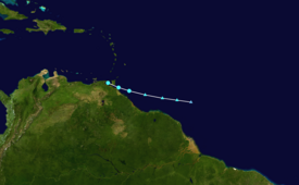
Bret continued moving swiftly to the west and struck Trinidad and Tobago early on June 20, before entering the Caribbean Sea, dissipating shortly afterwards.
[2] Deep convection flared sporadically as the wave moved westward under the influence of a mid-level ridge situated to the north during the next few days.
[3] ASCAT data around 12:00 UTC on June 18 indicated that a broad low pressure area developed, but lacked a well-defined circulation.
[5] Convection continued to increase on June 19, and around 18:00 UTC, a reconnaissance aircraft investigating the low found a well-defined center.
[1] Bret moved swiftly westward towards Trinidad and Tobago at speeds of nearly 30 mph (48 km/h), an unusually fast pace for a tropical cyclone, especially at such a low latitude.
The storm was not expected to intensify significantly or last long due to increasing vertical wind shear and land interaction with Venezuela.
[6] Early on June 20, a small central dense overcast formed near the center of Bret while satellite presentation improved.
Regeneration was not expected,[9] but after crossing Central America and entering the eastern Pacific, the remnants of Bret contributed to the development of Hurricane Dora on June 26.
[13] In preparation for the storm, businesses across Trinidad and Tobago advised employees not involved in essential services to remain home, and schools were closed.
[18] Gusty winds also impacted Trinidad, with a gust of 66 km/h (41 mph) being observed at the Piarco International Airport, where 6.7 centimetres (2.6 in) of rainfall had also been recorded through the overnight hours of June 19–20.
[19] One man died in Trinidad after slipping off a makeshift bridge and hitting his head on June 20, which was slippery after rainfall from the tropical storm; thus it is classified as an indirect death.
[31] Heavy rainfall in Venezuela caused flooding along coastal areas of the country; schools were temporarily closed on Margarita Island.
Tropical storm (39–73 mph, 63–118 km/h)
Category 1 (74–95 mph, 119–153 km/h)
Category 2 (96–110 mph, 154–177 km/h)
Category 3 (111–129 mph, 178–208 km/h)
Category 4 (130–156 mph, 209–251 km/h)
Category 5 (≥157 mph, ≥252 km/h)
Unknown

