2017 Atlantic hurricane season
Pre-season projections noted the potential for a weak to moderate El Niño event to evolve through the summer and fall on the basis of statistical model guidance.
Instead, equatorial Pacific Ocean temperatures began cooling throughout the summer, reaching La Niña threshold in November and curtailing the negative effects on Atlantic hurricane activity originally expected.
In addition, tropical Atlantic Ocean temperatures—previously below average in months prior to the start of the season—underwent rapid warming by late May, providing lower sea level pressures, weaker trade winds, increased mid-level moisture, and all-around a more conducive environment for above-average activity.
After an increase in shower and thunderstorm activity later on, as well as the development of a well-defined circulation, the system was classified as Tropical Storm Bret while located about 185 mi (298 km) east-southeast of Trinidad at 18:00 UTC on June 19.
A broad area of low pressure developed on June 19, and by 18:00 UTC on the following day, Tropical Storm Cindy formed over the central Gulf of Mexico about 240 mi (390 km) south-southwest of the mouth of the Mississippi River.
Because the cyclone had an asymmetrical structure, heavy rainfall was observed over southeastern Mississippi, southwestern Alabama, and the far western Florida Panhandle, while lesser precipitation amounts fell over Louisiana and Texas.
Three fatalities were attributed to the cyclone, one in Alabama after a boy was struck by a log pushed by waves,[55] another in Texas due to drowning,[57] and a third in Tennessee after a motorist skidded off a road and crashed into a pole.
[62] After the wave developed a well-defined circulation and a persistent mass of deep convection, Tropical Depression Four formed at 18:00 UTC on July 5, while situated about 1,545 mi (2,485 km) east of the Lesser Antilles.
[67] A combination of reconnaissance data and surface observations from the Windward Islands indicated that Don opened up into a tropical wave around 12:00 UTC on July 18, as it entered the eastern Caribbean Sea.
[68] Following the classification of Tropical Storm Emily, Florida Governor Rick Scott declared a state of emergency for 31 counties to ensure residents were provided with the necessary resources.
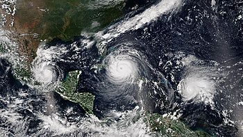
After reaching an initial peak with winds of 115 mph (185 km/h), Irma fluctuated in intensity over the next few days due to a combination of drier air and eyewall replacement cycles.
[38] Some weakening occurred south of the Bahamas, but the cyclone regained Category 5 intensity before making landfall on the Cayo Romano of Cuba at 03:00 UTC on September 9 with winds of 165 mph (270 km/h).
A large mid-latitude low-pressure area offshore Atlantic Canada and the circulation associated with Hurricane Irma resulted in the collapse of steering currents, causing Jose to decelerate and execute a cyclonic loop.
Remaining well offshore the East Coast of the United States, Jose re-intensified slightly further, attaining a secondary peak intensity as a high-end Category 1 hurricane with winds of 90 mph (150 km/h) around 12:00 UTC on September 17.
After passing north of the Gulf Stream, the cyclone encountered colder ocean temperatures and increasing wind shear, causing it to weaken to a tropical storm by 12:00 UTC on September 19.
[111] When Jose reached peak intensity, it marked the first time on record in the Atlantic basin that two hurricanes, the other being Irma, occurring simultaneously had maximum sustained winds of 150 mph (240 km/h).
The NHC upgraded the system to Tropical Storm Lee at 15:00 UTC on the next day, based on an increase in deep convection and an advanced scatterometer (ASCAT) pass which indicated that it was producing minimal tropical-storm-force winds.
An eyewall replacement cycle that night led to the emergence of a larger eye surrounded by cold cloud tops, and by 12:00 UTC on September 27, Lee reached its peak intensity as a Category 3 hurricane with winds of 115 mph (185 km/h).
Along the coastline of the mainland United States, tropical storm-force gusts cut power to hundreds of citizens; rip currents offshore led to four deaths and numerous water rescues.
A total of 146 people were confirmed to have been directly killed by the hurricane: 64 in Puerto Rico,[42] 65 in Dominica,[132] 5 in the Dominican Republic, 4 in the contiguous United States, 3 in Haiti, 2 in Guadeloupe, and 3 in the USVI.
Steered northwestward by a weak subtropical ridge to the northeast, the depression intensified into Tropical Storm Nate around 06:00 UTC on October 5, about six hours before it made landfall in northeastern Nicaragua.
Nate caused at least 50 deaths, including 16 in Nicaragua,[135] 14 in Costa Rica,[140] 7 in Panama, 5 in Guatemala, 3 in Honduras,[135] 4 in the United States,[135][139] and 1 in El Salvador, with a further 9 missing accumulative of all affected areas.
Late on October 11, the cyclone intensified into a hurricane and began curving northeastward in response to southwesterly flow associated with a broad mid-latitude trough and an approaching cold front.
Moving northeastward into a region of increasing wind shear and ocean temperatures less than 73 °F (23 °C), Ophelia began rapidly weakening early on October 15, while a strong upper-level trough and jet stream flow caused the storm to begin losing tropical characteristics.
Early on October 16, Ophelia ceased to be a tropical cyclone after merging with a strong cold front about 310 mi (500 km) southwest of Mizen Head, Ireland.
After the low acquired additional convection and the circulation became more well-defined, a tropical depression developed at 12:00 UTC on October 28, about 100 mi (160 km) south-southwest of Isla de la Juventud in Cuba.
Moving northeastward due to a large mid-latitude trough over the southeastern United States and western Gulf of Mexico, the depression intensified into Tropical Storm Philippe about six hours later.
As it started on a northerly track, Rina continued to strengthen despite strong shear and dry air intrusion, and also began to show subtropical characteristics marked by most of the deep convection and strongest winds well removed from the center.
Shortly after attaining peak strength, convection began to wane and became displaced well from the center of the system, while the overall structure became comma-like in appearance on satellite imagery, signifying that Rina was transitioning into a post-tropical cyclone.
[146] The NHC began monitoring a tropical wave that just emerged off the coast of Africa on August 13, which was expected to merge with an area of low pressure southwest of Cape Verde within a few days.