Tropical Storm Etau (2015)
Severe Tropical Storm Etau caused extensive and destructive flooding across eastern Japan during early September 2015.
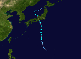
Tracking generally north, the cyclone gradually intensified and reached its peak strength with winds of 95 km/h (60 mph) on September 8.
Levee breaches took place along multiple rivers, most notably the Kinugawa which subsequently inundated the city of Jōsō.
[2] At this time the system was broad, weak and unorganized with deep atmospheric convection displaced over the north-western quadrant.
[6] Satellite image revealed that Etau had convection increasing near its center,[7] therefore, the JTWC upgraded it to a tropical storm.
[8] The system later reached its peak intensity as a severe tropical storm on September 8 with maximum sustained winds of 95 km/h (60 mph).
[9] Some weakening took place before the system made landfall over Chita Peninsula, Aichi, in the Chūbu region of Japan, early on September 9.
[15] The extreme rains prompted multiple emergency warnings from the JMA and Takuya Deshimaru stated that the situation posed "grave danger" to residents.
A 140 m (460 ft) section of a levee along the Kinugawa River in Ibaraki collapsed shortly after noon local time on September 10,[16][18] inundating the nearby city of Jōsō.
Significant damage took place at a fishing port in Chōshi; multiple vessels sank and driftwood cluttered the water.
[25] Drainage pumps at the crippled Fukushima Daiichi Nuclear Power Plant, which suffered critical meltdowns after the 2011 Tōhoku earthquake and tsunami, were overwhelmed on September 9 and allowed contaminated water to flow into the Pacific Ocean.
[27] An 800-year-old tree in Tarui, Gifu, a local natural monument, was felled from a combination of saturated soil and high winds produced by Etau.
[28] The extratropical remnants of Etau brought moderate rains to Primorsky Krai in the Russian Far East on September 10.
[13] A rescue attempt of a couple in Jōsō was aired live; however, the structure they were standing on collapsed and the feed was cut and their fate is currently unknown.
Tropical storm (39–73 mph, 63–118 km/h)
Category 1 (74–95 mph, 119–153 km/h)
Category 2 (96–110 mph, 154–177 km/h)
Category 3 (111–129 mph, 178–208 km/h)
Category 4 (130–156 mph, 209–251 km/h)
Category 5 (≥157 mph, ≥252 km/h)
Unknown
