Uranium mining in the Bancroft area
As a result of activities at its four major uranium mines, Bancroft experienced rapid population and economic growth throughout the 1950s.
During the Grenville orogenies, sedimentary rocks were transformed by heat and pressure into banded gneiss and marble, incorporating gabbro and diorite (rich in iron and other dark minerals).
Bancroft is unusual as one of the limited global locations where uranium is extracted from intrusive rocks, notably the only one from the pegmatite type.
[8] The key geological features in the Bancroft area relevant to uranium mining are three circular granitic complexes, each about 10 kilometres (6 mi) across.
[7]: 410 Aside from uranium, mines in the Bancroft area produced sought-after gemstones of 175 species, most notably calcite, clinohumite, corundum, diopside, dravite, edenite, euxenite-(Y), ferri-fluoro-katophorite, fluorapatite, fluorite, fluoro-richterite, ilmenite, kainosite-(Y), molybdenite, nepheline, phlogopite, crystals of the pyrochlore supergroup, thorite, titanite, tremolite, uraninite, uranophane, and zircon.
[2]: 192 His find was first called "the Richardson deposit" and later "the Fission property"[10]: 175 and is located 2 kilometres (1.2 mi) east of the Wilberforce community of Cardiff township.
[10]: 177 Between 1953 and 1956, 100 claims were staked around Bancroft[2]: 192 and at approximately the same time, another ten mines were started in the Elliot Lake area.
[13]: 48–49 Each of these used underground hard-rock mining methods to access and collect uranium ores from the surrounding granite and gneiss.
In 1952 G. W. Burns, an amateur prospector from Peterborough, found uranium deposits 16 kilometres (10 mi) southwest of Bancroft, near Cardiff township and Paudash Lake.
At another property near Centre Lake (between Cheddar and Cardiff), he observed purple rocks which he knew to be fluorspar, an indicator of radioactive geology.
[10]: 177–180 In late 1952, Burns sold his property to a Toronto syndicate that formed into the Centre Lake Uranium Mines Limited, led by C. C. Huston.
In 1955 the two sites were merged under the ownership of Bicroft Uranium Mines Limited, with work focused on the Centre Lake part of the property.
A treatment plant capable of processing 1,000 tonnes (1,100 short tons) of ore per day was built and operations started in late 1956.
[20]: 29 The uranium deposits of Bicroft mine occur in a set of eastward-dipping en-echelon lens-shaped dykes of syenite and granite, up to 24 m (80 ft) wide and 120 m (400 ft) long, which extend over an area of about 4.5 square kilometres (1.75 sq mi) within a north–south oriented belt of amphibolite and paragneiss (the eastern part of the Centre Lake granite).
In 1958, the treatment capacity was increased to 1,220 tonnes (1,350 short tons) per day in order to support processing of ore from Greyhawk Mine.
Other radioactive minerals found at this locality include allanite, cyrtolite (a uranium-thorium rich variety of zircon),[25] uranophane-α and uranophane-β.
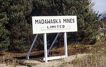
[10]: 184–185 Radioactive materials were first discovered in Faraday Township in 1955 by K. D. Thompson and M. Card, two employees of Goldhawk Porcupine Mines Limited who were surveying with Geiger counters.
Ore was transferred for processing at the Faraday Mine site, starting August 1957 at a rate of about 180 tonnes (200 short tons) per day.
Processing uranium ore from Bancroft cost $3.00 per ton[10]: 95 In the Greyhawk area, metagabbro is intruded by east–west trending pegmatitic granite dykes up to 18 m (60 ft) wide.
[2]: 192 The mine succeeded due to a combination of economic factors, including Bancroft's geographical proximity to the only uranium processing facility in Canada[33] (located at Port Hope) and a good road and rail network.
[2]: 192 Housing for miners was quickly established around the mines and in nearby Bancroft village, which extended to cover ten square kilometres (4 sq mi).
Other construction quickly followed, including two single-men's bunkhouses, a canteen, an eleven-room school, an ice-curling rink, and a recreation center.
Canadian Prime Minister John Diefenbaker, relying on an old agreement with the United Kingdom to buy uranium from Canada, was able to prolong the life of the mine by eighteen months, giving the community time to plan for the closure.
As a consequence of this, the primary hazards that are regulated are present only at Faraday/Madawaska Mine, and resulted in ongoing environmental monitoring by AECB's successor organization, the Canadian Nuclear Safety Commission (CNSC).
Public health concerns around groundwater contamination focus on uranium and thorium, plus the presence of decay products of both.
[44]: 2 1988 background radiation levels at parts of Paudash Lake were twenty times the safety limit and lumps of semi-refined uranium lay in the abandoned Dyno mine buildings.
[46] Tailings remain at Bicroft, Madawaska and Dyno mine sites where water sampling by the CNSC is ongoing.
[32]: 36 In 1974, the Ontario Workmen's Compensation Board studied 15,094 people who worked in uranium mines in Bancroft and around Elliot Lake for at least one month, between 1955 and 1974.
[32]: 79 Factoring in predicted lung cancer rate for men in Ontario led to the conclusion that by 1974 there were 36 more deaths than expected attributable to both Bancroft and Elliot Lake mines,[32]: 80 with the additional risk appearing to be twice as high for Bancroft miners compared to Elliot Lake miners.
[1]: 35 table 4 In an article published in The BMJ (journal of the British Medical Association) reported an increase of lung cancer risk; miners who have worked at least 100 months in uranium mines have a twofold increased risk of developing lung cancer.