Burnham-on-Sea
The position of the town on the edge of the Somerset Levels and moors where they meet the Bristol Channel, has resulted in a history dominated by land reclamation and sea defences since Roman times.
The name Burnham is derived from Burnhamm, as it was called in the will of King Alfred, made up from the Old English words Burna meaning stream and Hamm for enclosure.
When the Romans left, the system of drainage they installed was not maintained, and the areas reverted to become a tidal salt flat during the Anglo Saxon period.
[3] It is likely that at the time of the Norman Domesday book, settlements existed at Burnham and Huntspill, their common boundary running along what is now the Westhill Rhyne.
After the Second World War, further additions to the defences against the sea were added by bringing part of the remains of a Mulberry harbour used for the Normandy Landings, and burying them in the sand.
In 1944, she was used on aircraft training duties in the Western Approaches Command, which allowed a contingent from the ship to visit the town and march through its streets.
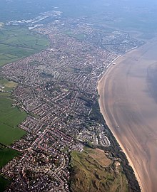
[7] Burnham-on-Sea is notable for its beach and mudflats, the danger they pose to individuals and shipping, and the efforts to which locals have gone in defending their town and preventing loss of life.
Burnham is close to the estuary of the River Parrett where it flows into the Bristol Channel, which has the second highest tidal range in the world.
[9][10] Burnham's extensive mud flats are characteristic of Bridgwater Bay and the rest of the Bristol Channel, where the tide can recede for over 1.5 miles (2.4 kilometres).
Bridgwater Bay consists of large areas of mud flats, saltmarsh, sandflats and shingle ridges, some of which are vegetated.
[12] Apex Leisure and Wildlife Park, in the south-west corner of Burnham-on-Sea, north of the River Brue, occupies an area of more than 42 acres (17 hectares).
The park was created from excavated clay pits, which were flooded, and the lakes are now home to many types of wildlife and leisure activities.
[13] Hinkley Point is a headland extending into Bridgwater Bay 5 miles (8 km) west of Burnham-on-Sea, one the opposite side the mouth of the River Parrett.
[15] In the summer the Azores high pressure affects the south-west of England, however convective cloud sometimes forms inland, reducing the number of hours of sunshine.
In 1911, a concrete sea wall was built, and after World War II further additions to the defences were made using the remains of a Mulberry harbour.
[16] Meteorological conditions resulted in a very intense secondary low-pressure area moving rapidly at 40 knots (74 km/h; 46 mph) into the Bristol Channel, with pressure dropping from 1,012 to 962 hectopascals (29.9 to 28.4 inches of mercury) between 00:00 and 18:00.
Over topping of the sea defences along a 7 mi (11 km) stretch of the Somerset coast at 22 locations from Clevedon to Porlock began after 19:30, and continued until about 21:30 when the wind speed had reached 50 knots (93 km/h; 58 mph) from the west.
Although there was no loss of life, the resultant flooding covered 12,500 acres (5,100 ha) of land, affecting 1,072 houses and commercial properties, with £150,000 worth of livestock killed and £50,000 of feed and grain destroyed.
400 properties were affected, with pavements, stone and concrete from the sea wall ripped up and the Esplande destroyed; total damage within the parish was estimated at £1.5M.
Burnham was a large ancient parish, and until the late 19th century included the then hamlet of Highbridge and rural areas around Edithmead.
[23] Because of its position near the mouth of the River Parrett, and the constantly shifting sands of the Bristol Channel, there has always been a significant risk to shipping in the area.
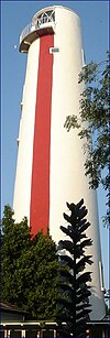
[24] The 110 ft (34 m) pillar or High Lighthouse was designed and built by Joseph Nelson for Trinity House in 1830, and equipped with a paraffin lamp.
[38] On the corner of Berrow Road and Sea View is a drinking fountain from 1897 with a single dressed stone pier and moulded plinth, topped by a cast iron urn.
[6] The church contains a number of marble carvings designed by Sir Christopher Wren for the private chapel in the Palace of Westminster.
Land side many activities cater for either the dominant resident elderly population or the seasonal tourists, including bowls,[47] and there is also a swimming pool and sports academy.
After winning the Tribute Somerset Premier in the 2008–09 they were promoted to the Western Counties North, a level seven rugby union league for clubs based in the south-west of England.
In 2016 the town held the Burnham Spray Jam which decorated the streets with artwork from John D'Oh, Andrew Burns Colwill, SPZERO, Irony, Cheba, Diff, Angus, The Agent, Miss Wah, 23 Magpies, Korp and many others.
Featuring workshops, demos, master classes alongside over 100 local producers from within 25 miles and lots of free entertainment.
[51] Thomas Alan Stephenson, a marine biologist, was born in the town in 1898,[52] and it was also the birthplace of John Pople, a theoretical chemist, in 1925.
[55] George Shelley of X Factor boy band Union J lived in Burnham-on-Sea and attended The King Alfred School, Highbridge, where he studied his GCSEs.


Spirit of Lelaina