Endorheic basin
[5] Endorheic basins constitute local base levels, defining a limit of the erosion and deposition processes of nearby areas.
[7] The term endorheic derives from the French word endoréisme, which combines endo- (Ancient Greek: ἔνδον éndon 'within') and ῥεῖν rheîn 'flow'.
[10][11] These endorheic watersheds (containing water in rivers or lakes that form a balance of surface inflows, evaporation and seepage) are often called sinks.
Their watersheds are often confined by natural geologic land formations such as a mountain range, cutting off water egress to the ocean.
In areas where rainfall is higher, riparian erosion will generally carve drainage channels (particularly in times of flood), or cause the water level in the terminal lake to rise until it finds an outlet, breaking the enclosed endorheic hydrological system's geographical barrier and opening it to the surrounding terrain.
The area containing Mexico City is one such case, with annual precipitation of 850 mm (33 in) and characterized by waterlogged soils that require draining.
[19] Endorheic regions tend to be far inland with their boundaries defined by mountains or other geological features that block their access to oceans.
In deserts, water inflow is low and loss to solar evaporation high, drastically reducing the formation of complete drainage systems.
As humans have expanded into previously uninhabitable desert areas, the river systems that feed many endorheic lakes have been altered by the construction of dams and aqueducts.
[22] Climate change coupled with the mismanagement of water in these endorheic regions has led to devastating losses in ecosystem services and toxic surges of pollutants.
[23] The desiccation of saline lakes produces fine dust particles that impair agriculture productivity and harm human health.
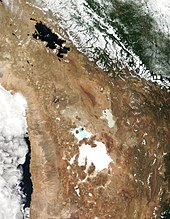
Many small lakes and ponds in North Dakota and the Northern Great Plains are endorheic, and some have salt encrustations along their shores.


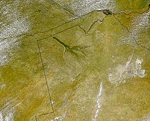


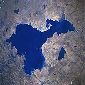

Image credit: NASA's Earth Observatory