Geography of Scotland
The geography of Scotland is varied from rural lowlands to unspoilt uplands, and from large cities to sparsely inhabited islands.
[3] The only land border is with England, which runs for 96 miles (154 kilometres) in a northeasterly direction from the Solway Firth in the west to the North Sea on the east coast.
[4] Separated by the North Channel, the island of Ireland lies 13 nautical miles (24 kilometres) from Mull of Kintyre on the Scottish mainland.
The Atlantic Ocean, which fringes the coastline of western and northern Scotland and its islands, influences the temperate, maritime climate of the country.
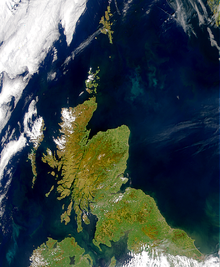
[7] The faultline separates two distinctively different physiographic regions; namely the Highlands to the north and west and the Lowlands to the south and east.
[8] The more rugged Highland region contains the majority of Scotland's mountainous terrain, including the highest peak, Ben Nevis.
An abundance of natural resources such as coal, iron and zinc contributed significantly to the industrial growth of Scotland during the 19th and early 20th centuries.
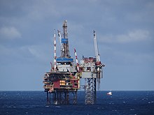
[11] Whilst Scotland is a large producer of petroleum, the production potential of renewable energy has emerged as an important economic and environmental issue in recent years.
The major division of Scotland is the Highland Boundary Fault, which separates the land into 'highland' to the north and west, and 'lowland' to the south and east.
By the Tertiary period, the tectonic plates were again moving, separating into modern-day North America and Europe with the creation of the Atlantic Ocean.
In the south of Scotland lie the Southern Uplands, a vast, rolling mountain chain that is less rugged and more forested than the Highlands.
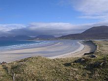
Parts of the Scottish coastline consist of a machair formation, a dune pasture land formed as sea levels subsided.
Other strong tides are to be found in the Pentland Firth between mainland Scotland and Orkney, and the Grey Dog between Scarba and Lunga.
Mull, Skye and Arran are noted for their mountainous terrain, whilst Tiree and Coll are flat or low lying.
[21][22] Scotland's only land border is with England, and runs for approximately 60 miles (100 kilometres) between the basin of the River Tweed on the east coast and the Solway Firth in the west.
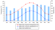
[6] Scotland is warmed by the North Atlantic Drift and given the northerly location of the country, experiences much milder conditions than areas on similar latitudes, such as Labrador in Canada—where icebergs are a common feature in winter.
[28] In common with the rest of the UK and Ireland, wind prevails from the south-west, bringing warm, wet and unstable air from the Atlantic.
[6] The windiest areas of Scotland are in the north and west, with parts of the Outer Hebrides, Orkney and Shetland experiencing over 30 days with gales per year.
[30] Scotland's share of the United Kingdom population has been declining in recent years and stands at just over 8.5% due to differential rates of growth in the home nations.
[31] However, an increasing birth rate[32] and higher levels of inward migration to Scotland have reversed the decline and contributed to the recent population growth.
[34] As a result, the majority of the population live in the Central Lowlands of Scotland, surrounding the chief cities of Glasgow and Edinburgh.
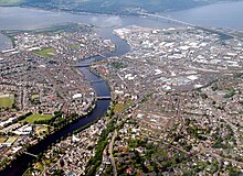
[35] Other concentrations of population include the northeast coast of Scotland – principally surrounding the city of Aberdeen and its environs – and around Inverness.
[34] Nearly 100 of Scotland's islands are inhabited, the most populous being Lewis and Harris with 21,031 people resident in 2011, primarily concentrated around Stornoway, the only burgh of the Outer Hebrides.
[38] Major towns in Scotland based on population include Paisley, East Kilbride, Kilmarnock, Livingston, Hamilton, Ayr, Cumbernauld, Irvine, Coatbridge and Wishaw.
[54] Originally an independent country, Scotland joined with England to form the Kingdom of Great Britain in 1707 with the Acts of Union.
Following the election, the third Sturgeon government was formed, initially consisting of just the SNP but later including the appointment of Slater and Harvie as junior ministers, after the two parties negotiated a power-sharing agreement.
Despite any suggestiveness of the etymons "high" and "low", the division of Highlands and Lowlands does not thoroughly correspond either to elevation or to latitude in the sense of Northern Scotland and Southern Scotland being "upper" and "lower" (as north and south are often termed in various countries), and yet interestingly, the division does bear some noticeable degree of correspondence to both elevation and latitude, with upward and northward both tending toward stronger Highlander identity, more preservation of Gaelic versus Scots, and other political differentials (e.g., in previous centuries, degree of Unionism, degree of Jacobitism, and others).
[65] Major industries include banking and financial services, steelmaking, transport equipment manufacturing, oil and gas, agriculture, whisky distilling, and tourism.
By Gross Domestic Product (GDP) figures, Glasgow City is the second highest amongst Scottish areas, behind, Edinburgh, and ahead of Aberdeen and Aberdeenshire.
[70][71] The petroleum industry in Aberdeen, the third most populous city in Scotland, began in the mid-20th century following the discovery of significant oil deposits in the North Sea.