Hurricane Alicia
Hurricane Alicia was a small but powerful tropical cyclone that caused significant destruction in the Greater Houston area of Southeast Texas in August 1983.
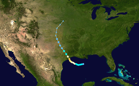
The cyclone was named on August 14 when it became a tropical storm, and the combination of weak steering currents and a conducive environment allowed Alicia to quickly intensify as it drifted slowly westward.
Alicia's approach precipitated the evacuation of 60–80 thousand people from coastal communities along the coasts of Southeast Texas and Louisiana.
Along the coast, a 12 ft (3.7 m) storm tide flooded communities, with the rough surf sinking several ships and resulting in three offshore fatalities.
In Downtown Houston, nearly all skyscrapers saw the loss of approximately half of lower-level windows, littering the urban streets with debris.
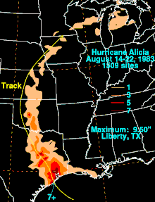
In addition to the strong winds, rough surf, and heavy rain, Alicia also generated 22 tornadoes centered around the Houston–Galveston area; most were rated F0, but the strongest, an F2, tore through Corsicana further north.
[1] This weak front was initially stationary over the Southeastern United States but moved slowly southward into the north-central and northeastern fringes of the gulf, producing strong convective activity beginning on the night of August 13, 1983.
[2] On August 14, a small area of low pressure developed on the western end of the front and moved off the coasts of Mississippi and Alabama, intensifying as it progressed further into the open gulf waters.
By the evening of August 14, the disturbance had largely separated from the parent frontal trough and continued to organize around a surface-level circulation.
[2] A United States Air Force reconnaissance aircraft investigated the precursor system and determined that it had developed into a tropical depression at 12:00 UTC (7:00 a.m. CDT) on August 15 while 160 mi (260 km) south of New Orleans, Louisiana.
The presence of a ridge of high pressure to Alicia's north steered the nascent tropical cyclone slowly westward in the early part of its development.
The ridge eventually drifted eastward, resulting in Alicia slowly curving towards the northwest beginning mid-day on August 16.
[1] The storm's slow movement—averaging just 5 mph (8 km/h)—and lack of strong steering currents allowed Alicia to reap highly favorable conditions characterized by warm sea surface temperatures in excess of 84 °F (29 °C) and favorable winds in the upper troposphere due to an upper-level anticyclone, resulting in unabated intensification until landfall.
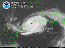
[1][4] At 06:00 UTC (1:00 a.m. CDT) on August 18, Alicia became a major hurricane and made landfall an hour later on Galveston Island—25 mi (40 km) southwest of Galveston, Texas—with maximum sustained winds of 115 mph (185 km/h) and a minimum barometric pressure of 962 mbar (hPa; 28.41 inHg) as measured by aircraft reconnaissance,[4][5] making it a low-end Category 3 on the Saffir–Simpson hurricane wind scale.
[11] The first gale warnings and hurricane watches were issued for the United States Gulf Coast between Corpus Christi, Texas and Grand Isle, Louisiana at 16:00 UTC (11:00 a.m. CDT) on August 16.
[12] Between 60 and 80 thousand people were evacuated from Brazoria, Chambers, Galveston, and Harris counties in advance of Alicia, as well as 1,500 persons from Sabine Pass.
Galveston Mayor E. Gus Manuel, against the advice of Texas Governor Mark White, ordered the evacuation of only low-lying areas.
In contrast, about 30 percent of Galveston's population evacuated the island when Hurricane Allen threatened the eastern Texas coastline in 1980.
[1] Despite being a relatively small and low-end Category 3 hurricane, the impacts of Alicia were exacerbated in the Houston metropolitan area due to a rapid increase in population, resulting in a rise in potentially susceptible infrastructure that also induced as much as 10 ft (3.0 m) in land subsidence along some stretches of Galveston Bay.
[8][12] Alicia produced a 12 ft (3.7 m) storm tide that crested along the interior coast of Galveston Bay near Baytown, Texas.
[12] A tug capsized 50 mi (80 km) south of Sabine Pass, resulting in one death and the eventual rescue of four crewmembers five days later.
Heavy rains nearing 8 in (200 mm) totals on the island caused street flooding and destroyed a mobile home community.
Similar debris or water blocked over 20 major roads; flooding caused by the widespread 5–8 in (130–200 mm) rainfall was most severe in Baytown, Clear Lake, and Pasadena in the eastern part of Harris County, necessitating the rescue of roughly 300 people.
Elsewhere in East Texas, Alicia's strong winds and heavy rains blocked power and water supplies in several cities.
[20][19][22] One F1 tornado in Harris County damage two businesses near the intersection of Interstate 45 and Texas State Highway NASA Road 1.
The tornado touched down in the morning of August 18 in the western extents of Corsicana and lasted for five minutes on a 3 mi (4.8 km) track, damaging several buildings including homes, a church, and a horse arena.
[13] Near El Reno, Oklahoma, 4–7 in (100–180 mm) of rain fell within a 5-hour period, resulting in significant flooding west of the town.
[25] Due to the severe damage caused by the hurricane, the name Alicia was retired in the spring of 1984 by the World Meteorological Organization, and will never be used again for another Atlantic tropical system.
Tropical storm (39–73 mph, 63–118 km/h)
Category 1 (74–95 mph, 119–153 km/h)
Category 2 (96–110 mph, 154–177 km/h)
Category 3 (111–129 mph, 178–208 km/h)
Category 4 (130–156 mph, 209–251 km/h)
Category 5 (≥157 mph, ≥252 km/h)
Unknown