Hurricane Felicia (2009)
Further strengthening ensued, and Felicia peaked in intensity as a Category 4 hurricane with sustained winds of 145 mph (233 km/h) and a barometric pressure of 935 mbar (hPa; 27.61 inHg).
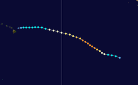
On August 11, Felicia weakened to tropical depression status, and soon degenerated into remnant low just prior to passing over the islands.
Hurricane Felicia originated from a tropical wave that moved off the west coast of Africa into the Atlantic Ocean on July 23, 2009.
The system remained ill-defined until August 1, at which time convection began to increase and the wave showed signs of organization.
[1][8] Located within an area of low wind shear and high sea surface temperatures, averaging between 28 and 29 °C (82 and 84 °F),[3] the storm quickly developed, with deep convection persisting around the center of circulation.
These conditions were anticipated to persist for at least three days; however, there was an increased amount of uncertainty due to possible interaction with Tropical Storm Enrique.
[11] Late on August 4, the intensity of Felicia led to it taking a more northward turn in response to a mid- to upper-level trough off the coast of the Western United States.
[13] Maintaining a well-defined eye, Felicia neared Category 4 status[14] and hours later, the storm attained winds of 140 mph (230 km/h) and a pressure of 937 mbar (hPa; 27.67 inHg) during the evening hours, making it the strongest Pacific storm east of the International Date Line since Hurricane Ioke in 2006[1][15] and the strongest in the eastern Pacific basin since Hurricane Daniel of 2006.
[1][2] Around 5:00 pm PDT (0000 UTC August 6) Felicia reached its peak intensity with winds of 145 mph (233 km/h) and a minimum central pressure of 935 mbar (hPa; 27.61 inHg).
[17] Early the next day, the structure of the hurricane quickly deteriorated as convection became asymmetric and cloud tops warmed significantly.
[20][21] Around 11:00 am HST (2100 UTC), the Central Pacific Hurricane Center (CPHC) took over responsibility of issuing advisories as Felicia crossed longitude 140°W.
[26] Several hours after being downgraded, the CPHC issued its final advisory on Felicia as it degenerated into a remnant low near the Hawaiian Islands.
[42] On August 6, the Red Cross stated that it was deploying a disaster recovery team, led by the director of the agency, to the islands of Hawaii.
[43] On August 7, five Hurricane Hunter planes were dispatched to Hickam Air Force Base to fly missions into the storm.
[44] Later that day, the Central Pacific Hurricane Center issued tropical storm watches for the island of Hawaii, Maui, Kahoolawe, Lanai, and Molokai.
[46] The watches for the Big Island were later cancelled as the forecast track appeared to drift further north toward Maui County and Oahu.
[50] In Oahu, areas on the windward side of the island received more than 1 in (25 mm) of rain on August 12 from the remnants of Felicia, causing many roads to become slick.
[64] Officials were forced to close the beaches along Hanauma Bay after swells from Felicia pushed an estimated 2,000 Portuguese Man o' War siphonophorae into the region.
Tropical storm (39–73 mph, 63–118 km/h)
Category 1 (74–95 mph, 119–153 km/h)
Category 2 (96–110 mph, 154–177 km/h)
Category 3 (111–129 mph, 178–208 km/h)
Category 4 (130–156 mph, 209–251 km/h)
Category 5 (≥157 mph, ≥252 km/h)
Unknown


