Hurricane Jimena (2009)
Forming from a tropical wave late on August 28, 2009, off of Mexico's Pacific coast, the system rapidly intensified into a Category 2 hurricane on the next day.
In Baja California Sur, the town of Mulegé was devastated with other areas in the region also receiving major damage.
[1] On August 25, the National Hurricane Center began monitoring a broad area of low pressure, while the system was located over Central America.
[4] However, shower and thunderstorm activity began to increase and an area of low pressure developed within the wave on August 27.
Tracking westward in response to a mid-level ridge over Mexico, the depression intensified into a tropical storm on 0000 UTC August 29.
[1] Despite weakening slightly, Jimena was anticipated by meteorologists to still remain a major hurricane as the storm moved ashore.
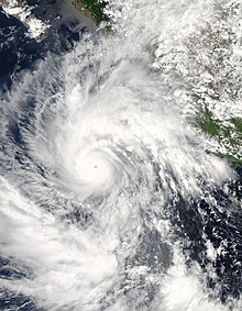
On September 1, Hurricane hunters found Jimena weaker, reporting winds of 145 mph (233 km/h) and a pressure of 940 mbar (940 hPa; 28 inHg).
[12] On 1200 UTC September 2, Jimena made landfall on Isla San Margarita, Baja California del Sur with winds of 105 mph (169 km/h) and a pressure of 971 mbar (971 hPa; 28.7 inHg).
After emerging into the Gulf of California, steering currents collapsed and increased wind shear continued to weaken Jimena.
With winds of 30 mph (48 km/h), the system made a fourth and final landfall near Santa Rosalía, Baja California Sur.
[3] As the storm moved parallel to the Mexican coast, interests in the region were asked to watch the progress of the system[9] and officials in the area opened shelters due to the risk of high winds.
[15] Early on August 31, about 54 hours prior to landfall, the Government of Mexico issued a hurricane watch from Bahia Magdalena to San Evaristo in the southern Baja California peninsula.
[22] In addition, the states of Guerrero, Colima, and Jalisco suffered mudslides, landslides, and heavy rain from outer rainbands related to the system.
[23] When the tropical cyclone passed over the Baja California Peninsula, storm chasers in Puerto San Carlos reported a minimum pressure of 973 mbar (973 hPa; 28.7 inHg).
In addition, 75% of homes were damaged in Puerto San Carlos, and power was lost in many areas including Comondú and Loreto.
[24] Seventy percent of the electric network form Santa Rosalía to Ciudad Constitución was damaged due to power outages.
The roads from San José del Cabo to Tijuana was affected because any nearby creeks overflowed their banks.
[32] The peak 24-hour rainfall record was set by Jimena as it ultimately topped out at 26.1 in (660 mm)[33] while 43.39 inches (110.2 cm) of rain was reported in 36 hours.
[34] The towns of Guaymas and Empalme became unreachable from the rest of the state because Mexico Federal Highway 15 was closed due to flooding.
Marina Seca was badly damaged, with boats being washed out over the highway onto the beaches, where there was no water, telephone, or internet services for over 15 days.
[42] While the storm was weakening, a cold front lifted deep tropical moisture that triggered flash flooding and severe weather in the Mojave Desert.
[43] In San Diego County, California, a severe thunderstorm rolled through the area midday on September 5, breaking 19 pipelines and causing $100,000 in damage.
[48] Near the town of Ocotillo Wells, flash flooding was reported due to heavy rainfall, causing an additional $20,000 in damage.
[49] Strong winds associated with the thunderstorms downed power lines and resulted in dust storms across the Imperial Valley, some of which reduced visibility by up to 25%.
[53] Northwest of Golden Valley, severe thunderstorms produced golf ball sized hail, roughly 1.75 in (44 mm) in diameter, that broke windows.
[58] In Tanca, about 1 in (25 mm) of rain fell in 30 minutes, resulting in flash flooding that washed out a road and damaged a business.
[59] Shortly after the hurricane made landfall, Mexico's natural disaster fund provided $1.45 million in aid to repair pipelines, highways, and buildings.
[30] The United Methodist Committee on Relief distributed food baskets to 720 survivors and provided 180 families with wood for rebuilding their homes.

Tropical storm (39–73 mph, 63–118 km/h)
Category 1 (74–95 mph, 119–153 km/h)
Category 2 (96–110 mph, 154–177 km/h)
Category 3 (111–129 mph, 178–208 km/h)
Category 4 (130–156 mph, 209–251 km/h)
Category 5 (≥157 mph, ≥252 km/h)
Unknown