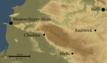
Mendip Hills
[2] The higher, western part of the hills, covering 198 km2 (76 sq mi) has been designated an Area of Outstanding Natural Beauty (AONB), which gives it a level of protection comparable to a national park.
There has been a great deal of debate, over the course of decades if not centuries, about the provenance and meaning of the toponym 'Mendip', and as late as 2000, two leading place-name scholars felt able to remark that "Mendip is probably best regarded as unsolved"[4].
However, an idea put forward in a 1986 paper, by one of the UK's leading academic place-name researchers, seems to have regrettably fallen beneath the radar, and has not had the widespread currency that it deserves.
The logic and elegance of this explanation is extremely clear - the Mendip plateau had been used explicitly as a hunting ground by the Anglo-Saxon kings, something strikingly reinforced by the (possibly apocryphal) story of King Edmund, in the middle of the 10th century, escaping death by a whisker as the stag he was chasing plunged to its death over Cheddar Gorge, his own horse only pulling up short at the last minute on the very lip of the cliff.
[6] Subsequently, much of northwestern Europe underwent continental collision throughout the late Paleozoic Era, culminating in the final phases of the Variscan orogeny near the end of the Carboniferous, 300 million years ago.
This tectonic activity produced a complex suite of mountain and hill ranges across what is now southern Ireland, south-western England, Brittany, and elsewhere in western Europe.
[7] As a result of the Variscan mountain-building, the Mendip area now comprises at least four anticlinal fold structures, with an east–west trend, each with a core of older Devonian sandstone and Silurian volcanic rocks.
[10] The Mendips were considerably higher and steeper 200 to 300 million years ago,[11] and subsequent erosion has resulted in varying geological features including gorges, dry valleys, screes, swallets and others typical of karst landscapes.
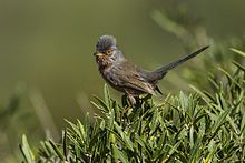
The upland heaths of the west Mendips have recently increased in ornithological importance due to colonisation by the Dartford warbler (Sylvia undata), which can be found at Black Down and Crook Peak.
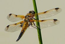
The Waldegrave Pool, part of Priddy Mineries, is an important site for dragonflies, including downy emerald (Cordulia aenea) and four-spotted chaser (Libellula quadrimaculata).
A rare and endangered species, the greater horseshoe bat is protected under the Wildlife and Countryside Act 1981 and is listed in Annex II of the 1992 European Community Habitats Directive.
Several rare butterflies are indigenous to the area, including the nationally scarce pearl-bordered fritillary (Boloria euphrosyne), Duke of Burgundy (Hamearis lucina), and white-letter hairstreak (Satyrium w-album).
[28] Amongst the plants which occur in the area are the Cheddar pink (Dianthus gratianopolitanus), purple gromwell (Lithospermum purpurocaeruleum), white rock-rose (Helianthemum apenninum), Somerset hair-grass (Koeleria vallesiana), and starved wood-sedge (Carex depauperata).
The second was represented in the Iron Age Britain and Roman periods by large sites with specialist functions, existing by virtue of their ability to exert power over lowland producers.
From the Iron Age onward the ownership of land took on increasing importance, with large landholdings based on the mines or on stock grazing, denying settlers access to the plateau or forcing them off the hills.
The Roman invasion, and possibly the preceding period of involvement in the internal affairs of the south of England, was inspired, in part, by the mineral wealth of the Mendips.
[39] William Wilberforce's visit to Cheddar in 1789, during which he saw the poor circumstances of the locals, inspired Hannah More to begin her work improving the conditions of the Mendip miners and agricultural workers.
Between 1770 and 1813 some 7,300 ha (18,000 acres) of land on the hills were enclosed, mainly with dry stone walls that today form a key part of the landscape.
[41] In World War II, a bombing decoy was constructed on top of Black Down at Beacon Batch in an attempt to confuse bombers aiming to damage the city of Bristol, and piles of stones (known as cairns) were created to prevent enemy aircraft using the hilltop as a landing site.
The proposal was initially rejected by Mendip District Council, with the support of a range of local groups and organisations, on the grounds that the environmental impact on the edge of the AONB outweighed the amount of electricity which would be generated.
[44][45] The western end of the Mendip Hills has, since 1972, been designated an Area of Outstanding Natural Beauty (AONB) under the National Parks and Access to the Countryside Act 1949.
[50] The Mendip Hills Partnership, which performs an administrative role, includes the five local authorities that cover the AONB, statutory bodies such as Natural England, together with parish councils and other organisations and groups that have an interest in the conservation and care of the area.
[51] In 2005 a proposal was submitted to the Countryside Agency to extend the Area of Outstanding Natural Beauty to Steep Holm and Brean Down in the west and towards Frome in the east.
[3] The population on the higher plateau is widely dispersed in small farms and hamlets, although rather than working in agriculture or forestry, most people now commute to employment in surrounding cities and towns.
Axbridge, with a population of 2,057,[54] and Cheddar (5,755),[54] both within the Sedgemoor district, together with the Mendip town of Shepton Mallet (10,369)[55] and the city of Wells (10,636)[56] are along the southern border of the hills.
In the middle of the 1st century, ancient tracks across the hills were superseded by the Roman Fosse Way, from Bath to Ilchester, a branch of which served the Charterhouse lead mines.
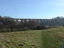
[68][69][70][71][72] In recent centuries the Mendips, like the Cotswolds to the north, have been quarried for stone to build the cities of Bath and Bristol, as well as smaller towns in Somerset.
Families and individuals take part in activities including skiing and snowboarding, climbing and abseiling, kayaking and paddle boarding, caving, archery, air rifle, tobogganing and disc golf.
[86] Many caves in the Mendip area were excavated for archaeological and natural history studies by pioneer explorer Herbert E. Balch and were photographed by the early caver Harry Savory at the start of the 20th century using cameras, glass plates and flash powder.
The western section runs from the Bristol Channel at Uphill Cliff, affording views over the Somerset Levels, crosses the central Mendip plateau leading down to Cheddar Gorge, and then continues to Wells and Frome.