Portishead, Somerset
A power station and chemical works were added in the 20th century, but the dock and industrial facilities have since closed and have been redeveloped into a marina and residential areas.
Run solely by local Royal National Lifeboat Institution (RNLI) volunteers, it serves the waters of the Severn estuary and inland waterways into the city of Bristol.
[5] The town's recorded history dates back to Roman times,[4] although there is also evidence of prehistoric settlement, including polished flint axe heads.
[7] There is some evidence that it may have been the western end of the Wansdyke, an early medieval or possibly Roman boundary with a series of defensive linear earthworks extending to the Savernake Forest near Marlborough in Wiltshire.
[8] After the Norman conquest the manor was held by the Bishop of Coutances and later reverted to the Crown, after which William II gave it to a merchant from Bristol known as Harding and then to his son Robert Fitzharding, who became Lord of Berkeley.
The old pill or jetty provided protection for craft against the Bristol Channel's large tidal range,[6] and iron rings can be seen in the high street at which fishing boats used to moor.
[6] The King Road was the site of a naval action in 1758 when HMS Antelope captured Belliqueux, one of a French squadron returning from Quebec.
[6] The Royal Hotel by the pier was built in a Tudor Gothic style in 1830,[12] to provide accommodation and catering for travellers on the steamers from Bristol, Wales and Ireland.
governing the enclosure of Portishead was passed in 1814, and stipulated the right to a public wharf, although there is historical evidence of nautical connections dating back to the Patent Rolls of 1331.
They used some local coal produced in the Somerset coalfield, which was delivered by train along the Portishead branch of the Great Western Railway (GWR).
[13] The main supply of coal was imported by boat from Newport and Ely in South Wales; it was carried by Osborn & Wallis of Bristol.
[20] In 2009 a report by the Association of Train Operating Companies stated that the Portishead branch was a special case for future consideration for reopening due to the large projected increase in population and congestion in the area.
The former deep-water dock, used to supply coal and goods to the power stations, has been fully redeveloped into a modern marina with 250 pontoon berths.
New waterside bars and restaurants, including Hall & Woodhouse, Aqua, Bottelinos, Costa Coffee have opened around the marina as well as a nearby Wetherspoons.
[30] The radio station played a vital role during the Second World War in maintaining communications with the British merchant navy and with patrol aircraft in the North Atlantic.
In 1943, the workload was so great that a Royal Navy officer and 18 telegraphists were brought in from HMS Flowerdown, a Naval Shore Wireless Service station near Winchester.
[31] By the end of the 1980s, satellite communications had started to take an increasing share of the station's business, and a programme of severe rationalisation began, leading to the closure of two transmitting sites at Leafield and Ongar.
Planning permission was granted in October 2007 for a development of 190 houses and flats on the site and shortly afterwards the old radio station buildings were demolished.
It lies north east of Clevedon and immediately south west of Avonmouth just across the River Avon, which forms the boundary between Somerset and Bristol.
The tidal rise and fall in the Severn Estuary and Bristol Channel can be as great as 49 ft (15 m),[48] second only to Bay of Fundy in Eastern Canada.
[49][50] There has been concern about pollution levels from industrial areas in Wales and at the eastern end of the Bristol Channel; however, this tends to be diluted by the Atlantic waters.
[52] Eastwood and Battery Point Local Nature Reserve is a 9 hectares (22 acres) woodland containing Yew, Maple, Dogs mercury and beech.
The annual mean temperature is about 10 °C (50 °F) with seasonal and diurnal variations, but the modifying effect of the sea restricts the range to less than that in most other parts of the United Kingdom.
[57][59] Portishead had a population of 22,000 in 2016,[4] an increase of over 3,000 since the figure of 17,130 recorded in the 2001 census,[60] with a growth rate of 40 per cent; which is considerably in excess of surrounding towns.
[61] As the result of a house-building programme, a further 8,000 people are expected to settle in the area by 2026,[62] making Portishead one of the largest towns in North Somerset.
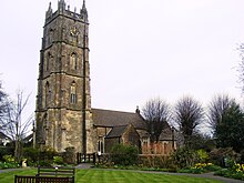
The Grade II* listed building[63] is owned by Bristol City Council and in 2010 protests from local residents attempted to stop its sale.
[80] The main A369 road — known after the historical name for the area as "The Portbury Hundred",[81] which links the town to the nearby M5 motorway — is prone to congestion, especially during rush hours.
[85][86] Portishead is served by bus routes, including a half-hourly service to Bristol; as well as local buses to Nailsea and Weston-super-Mare.
Other sporting facilities in the town include open-air tennis courts, a large outdoor swimming-pool opened in 1962 (and renovated in 2009),[95] a boating lake, cricket ground, football and hockey pitches as well as many cycle lanes.
[115] In 1992 a further twinning arrangement was made with Schweich, the principal town in a municipality of some 20,000 people, 6 miles (9.7 km) from the Roman city of Trier.