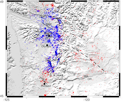
Puget Sound faults
Thick glacial and other deposits, heavy vegetation, urban development, and a topography of sharp relief and rapid erosion obscures the surface expression of faults in this region, and has hindered their discovery.
[10] Discovery of faults has been greatly facilitated with the development of LIDAR, a technique that can generally penetrate forest canopy and vegetation to image the actual ground surface with an unprecedented accuracy of approximately one foot (30 cm).
An informal consortium of regional agencies has coordinated LIDAR mapping of much of the central Puget Lowland, which has led to discovery of numerous fault scarps which are then investigated by trenching (paleoseismology).
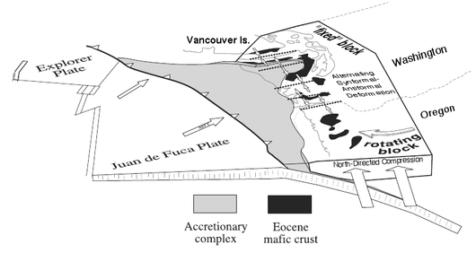
This pocket is catching a stream of terranes (crustal blocks about 20 to 30 km thick[18]) which the Pacific plate is pushing up the western edge of North America, and in the process imparting a bit of clockwise rotation to southwestern Washington and most of Oregon; the result has been characterized as a train wreck.
The principal effects of this complex interplay of forces on the near-surface crust underlying the Puget Lowland are: Further complicating this is a feature of unknown structure and origin, the Olympic–Wallowa Lineament (OWL).
A principal finding is that "[c]rustal seismicity in the southern Puget Sound region appears to be controlled by a key block of Crescent Formation occurring just south of the Seattle fault.
[39] On the basis of marine seismic reflection surveying in the Strait of Juan de Fuca it has been suggested that the DMF, SPF, and UPF are structurally connected (at least in the segment crossing Whidbey Island).
[49] Yet it is also notable that "most seismicity in the northern Puget Sound occurs along and southwest of the southern Whidbey Island fault at typical depths of 15–27 km within the lower part of the Crescent Formation.
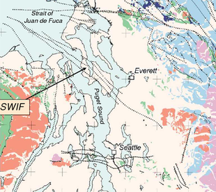
[51] Prior to 2000, prominent aeromagnetic anomalies strongly suggested that the fault zone continued southeast, perhaps as far as the town of Duvall, but this was uncertain as the SWIF is largely concealed, and the faint surface traces generally obliterated by urban development.
One study compared the relative elevation of two marshes on opposite sides of Whidbey Island, and determined that approximately 3,000 years ago an earthquake of M 6.5–7.0 caused 1 to 2 meters of uplift.
[60] Such seismic hazards were a major issue in the siting of the plant, as it is tucked between two active strands, and the influent and effluent pipelines cross multiple zones of disturbed ground.
[62] These ridges (part of a broader regional pattern that reflects the roots of the former Calkins Range[63]) are formed of sediments that collected in the Everett basin during the Eocene, and were subsequently folded by northeast-directed compression against the older Cretaceous and Jurassic rock to the east that bound the Puget Lowland.
At the edge of this older rock is the Rogers Belt, a geologically interesting zone running from the area of Sultan (due east of Everett) to Mount Vernon (just north of the bend in the Devils Mountain Fault).
[75] The strongly expressed topographical lineaments at the north end of the Rogers Belt pose a perplexing problem, as they show no definite offset where they are bisected by the left-lateral oblique-slip Devils Mountain Fault.
[85] The Tokul Creek Fault (TCF) strikes NNE from Snoqualmie, aligned with a possible offset of the Western Melange Belt[86] and with a valley that cuts through to the Skykomish River; it is now believed to be of regional significance.
West of Puget Sound the tectonic basement of the Coast Range geologic province is the approximately 50 million year (Ma) old marine basalts of the Crescent Formation, part of the Siletzia terrane that underlies western Washington and Oregon.
In the wedge model of Pratt et al. (1997) a slab of rock – mainly basalts of the Crescent Formation – about 20 km thick is being pushed up a "master ramp" of deeper material; this forms the Seattle Uplift.
[129] The western part is an active east–west striking north dipping reverse fault that separates the Seattle Uplift and the Tacoma Basin, with approximately 30 miles (50 km) of identified surface rupture.
[131] The Tacoma Fault was first identified by Gower, Yount & Crosson (1985) as a gravitational anomaly ("structure K") running east across the northern tip of Case and Carr Inlets, then southeast under Commencement Bay and towards the town of Puyallup.
This is the Dewatto lineament, believed to result from an east-dipping low-angle thrust fault where the western flank of the Seattle Uplift has been pushed into the northwestern corner of the Tacoma Basin.
If so, this would be a major fault system (over 185 km long), connecting the Puget Lowland with the Yakima Fold Belt on the other side of the Cascades, with possible implications for both the Olympic—Wallowa Lineament (which it parallels) and geological structure south of the OWL.
Kinematic analysis suggests that if shortening (compression) in the Puget Lowland is directed to the northeast (i.e., parallel to Hood Canal and the Saddle Mountain deformation zone) and thus oblique to the Dewatto lineament, it should be subject to both strike-slip and dip-slip forces, implying a fault.
Based on this and geophysical anomalies it was inferred that there is a major, active strike-slip fault zone running from the south end of Hood Canal, up Dabob Bay, and continuing north on land.
The Olympia structure – also known as the Legislature fault[168] – is an 80 km long gravitational and aeromagnetic anomaly that separates the sedimentary deposits of the Tacoma Basin from the basalt of the Black Hills Uplift (between lines A and B on the map).
Aeromagnetic mapping in 1999 showed a very prominent anomaly[172] (such as typically indicates a contrast of rock type); that, along with paleoseismological evidence of a major Holocene earthquake, has led to a suggestion that this structure "may be associated with faulting".
[176] A marine seismic reflection study[177] found evidence of faulting at the mouth of Budd Inlet, just north of the Olympia structure, and aligning with faint lineaments seen in the lidar imagery.
The WRZ and SHZ are associated with the southern Washington Cascades conductor (SWCC), a formation of enhanced electrical conductivity[194] lying roughly between Riffe Lake and Mounts St. Helens, Adams, and Rainier, with a lobe extending north (outlined in yellow, right).
[195] The southwestern boundary of the SWCC, where it is believed to be in near vertical contact with the Eocene basalts of the Crescent Formation, forms a good part of the 90 km (56 mile) long SHZ.
[199] It has been speculated that the SHZ might extend under the Kitsap Peninsula (central Puget Sound), possibly involved with a section of the subducting Juan de Fuca plate that is suspected of being stuck.
This MSH-MR-GP lineament is believed to reflect a "long-lived deep-seated lithospheric flaw that has exerted major control on transfer of magma to the upper crust of southern Washington for approximately the last 25 [million years]";[203] it has been attributed to the geometry of the subducting Juan de Fuca plate.


