River Parrett
Its source is in the Thorney Mills springs in the hills around Chedington,[3][4] 2.5 miles (4 km) from that of the River Axe, in nearby Beaminster, which runs in the opposite direction to the English Channel at Axmouth in Devon.
[39] The River Parrett, the Bristol Channel and the Severn Estuary are believed to have been used for riverine bulk transportation of people and supplies in Somerset under Roman and later Anglo-Saxon and Norman occupation.
[53] The White House Inn, a licensed victualler and part-owner of the ferry, traded on the Pawlett bank from 1655 to 1897; the building was retained as a farm dwelling for another 20 years.
[53] The Combwich river crossing, which was a main route until the 18th century, fell out of use due to turnpike trusts improving what were to become the A38 and A39 roads, and traffic went via Bridgwater; the former inn was demolished c. 1930.
Between 1677 and 1678, Sir John Moulton cut a new channel at "Vikings Creek" on the Horsey Levels to remove a large meander; the old river bed soon silted up, providing 120 acres (49 ha) of new land.
[58] The English Civil War put a stop to most reclamation work; however, in 1764 a clyse was built at Dunball to contain tidal influences on a run-off stream near King's Sedgemoor.
[65] It was the major port for Somerset which, around the Quantocks, the Brendon Hills and the Tone valley, was mainly agricultural, producing arable crops and vegetables to supply the new industrial towns.
[71] The brick and tile industry made use of the local alluvial clays and the Parrett's coastal trade, using ketches mostly based at Bridgwater to transport their products, which were heavy and bulky, and to bring in coal to heat the kilns.
[73] Silt was also dredged from the river over a 2-mile (3.2 km) stretch between Somerset Bridge and Castle Fields, Bridgwater, to make Bath bricks, an early abrasive cleaning material patented in 1827.
[86] This traffic ceased in the 1930s; in the late 1950s the wharf was taken over and upgraded by the Central Electricity Generating Board (CEGB) to bring in heavy materials for the Hinkley Point nuclear power stations.
[95] Although ships no longer dock in the town of Bridgwater, 90,213 tonnes (99,443 short tons) of cargo were handled within the port authority's area in 2006, most of which was stone products via the wharf at Dunball.
With the possible future construction of the two Hinkley Point C nuclear power stations by EDF Energy, it is proposed that Combwich wharf be employed to transfer heavy goods to the sites.
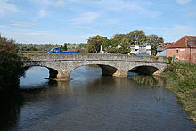
[103] Traffic on the higher reaches was hindered by shoals in the river and by the Great Bow Bridge at Langport, which consisted on nine small arches, none of them big enough for navigation.
There are no records of traffic, but it has been estimated at 60,000 to 70,000 long tons (61,000 to 71,000 t) per year, based on the toll receipts and the knowledge that the Stuckey and Bagehot boats carried about three-quarters of the total tonnage.
[9] There is still a public right of navigation as far as Oath Lock, but very few private boats use the river, largely due to the fierce tides in the estuary and a lack of moorings along its route.
The launch of The Duchess of Cocklemoor was witnessed by over 200 local people,[117] and the vessel has since had its diesel engine replaced by a 1.5 kW (2.0 hp) electric motor, powered by solar panels mounted on the roof.
An 80-foot (24 m) section of railway track to the east of the bridge could be moved sideways, so that the main 127-foot (39 m) girders could be retracted, creating a navigable channel which was 78 feet (24 m) wide.
The bridge was highlighted in a report made by William Armstrong in 1824, as a factor which would prevent the River Tone Navigation competing with the new Bridgwater and Taunton Canal, then being built.
[158] Engineering works were undertaken at the Parrett, King's Sedgemoor Drain, and River Brue systems, to try to ensure that the agricultural land benefited from a potable water supply in the groundwaters from the Quantock Hills to the coastline.
[1] In the 1970s a study was commissioned by Wessex Water to investigate the likely effects of constructing a tide-excluding barrier, aimed at stopping the silt, just upriver of Dunball Wharf on the hydraulic, sedimentary and pollutant regime of the estuary.
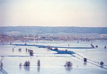
[164] Following summer floods of 1997 and the prolonged flooding of 1999–2000 the Parrett Catchment Project was formed, partly funded by the European Union Regional Development Fund, by 30 organisations, including British Waterways, Campaign to Protect Rural England, Countryside Agency, Department for Environment, Food and Rural Affairs, Environment Agency, Kings Sedgemoor and Cary Vale Internal Drainage Board (now part of Parrett Internal Drainage Board), Levels and Moors Partnership, National Farmers Union, Sedgemoor, Somerset County Council, South Somerset District Council, Taunton Deane and Wessex Water.
These include the conversion of arable land, adoption of the Sustainable Drainage Systems (SuDS) approach to controlling rainwater runoff from developed areas, dredging, raising riverbanks and improving pumping facilities.
[180] It is to be built between Express Park and Chilton Trinity, with two vertical lift gates to allow the waterway to be blocked to stop water from flowing upstream during very high tides in the Bristol Channel.
The geology of the area is that of two basins mainly surrounded by hills, the runoff from which forms rivers that originally meandered across the plain but have now been controlled by embanking and clyces.
The reduction in water levels that resulted put local ecosystems at risk; peat wastage in pasture fields was occurring at rates of 1–3 ft (0.3–0.9 m) over 100 years.
The central area contains a sward dominated by sheep's fescue (Festuca ovina) in combination with yellow oat-grass (Trisetum flavescens) and quaking-grass (Briza media).
Salad burnet (Sanguisorba minor) forms a major component of the sward with the two nationally rare species rough marsh-mallow (Malva setigera) and nit-grass (Gastridium ventricosum), also present.
[198] 282 American mink (Mustela vison) have been captured after their escape from breeding farms, which is encouraging water voles (Arvicola amphibius) to recolonise areas of the Levels where they have been absent for 10 years.
On the outskirts of Bridgwater at Huntworth the river passes several local nature reserves which provide roosts for thousands of common starlings (Sturnus vulgaris) each winter.
[18] Since 2000, attempts have been made to clarify the legal status and organisational responsibilities for the maintenance of the river and explore issues involving the sustainability and safe use of the waterway for a public trip boat and recreational craft.