Taunton
[2] Its thousand-year history includes a 10th-century monastic foundation, owned by the Bishops of Winchester, which was rebuilt as Taunton Castle by the Normans in the 12th century.
Today it hosts Musgrove Park Hospital, Somerset County Cricket Club, is the base of 40 Commando, Royal Marines, and is home to the United Kingdom Hydrographic Office on Admiralty Way.
[12] The bishops of Winchester owned the manor, and obtained the first charter for their "men of Taunton" from King Edward in 904, freeing them from all royal and county tribute.
Some time before Domesday, Taunton became a borough with privileges and a population of some 1,500,[11] including 64 burgesses[3] governed by a portreeve appointed by the bishops.
In the autumn of that year Judge Jeffreys lived in the town during the Bloody Assizes that followed the Battle of Sedgemoor.
[22] A fire aboard a Penzance to London sleeping car train approaching Taunton in 1978 killed 12 passengers and injured 15 others.
Taunton was rated "strategically important" in the government's Regional Spatial Strategy, allowing Somerset County Council to receive funding for large-scale regeneration projects.
This would see regeneration of the areas of Firepool, Tangier, the retail town centre, the cultural quarter, and the River Tone, to sustain Taunton as business hub in the South West.
[24] The Firepool area, just north of the town centre by the main railway station, includes vacant or undeveloped land.
[25] In Tangier, a brownfield area between Bridgwater and Taunton College and the bus station, the project proposed to build small offices and more riverside housing.
Projects to develop Somerset Square (a paved area next to the Brewhouse Theatre) and Longrun Meadow (a country park near Bridgwater & Taunton College) have been put forward.
[46] The several local nature reserves in and around Taunton are protected under Section 21 of the National Parks and Access to the Countryside Act 1949.
[47] The northern suburbs include the Children's Wood riverside reserve, a movement corridor for animals such as otters along the banks of the Tone.
[48] Weirfield Riverside, a nature reserve along the River Tone, has alder and willow woodland, bramble, scrub and rough grassland.
[53] In the summer the Azores high pressure affects the south-west of England, but convective cloud sometimes forms inland, reducing the sunshine hours.
[61] Taunton's ethnic mix resembles that of South West England – 91.8 per cent White British in the same year.
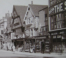
[72] The frontage of the Fore Street Tudor Tavern, now a Caffè Nero branch, dates from 1578, but the rest is thought to be from the 14th century.
regeneration programme north of Bridge Street will include redeveloping the County Cricket Ground, which hosted open-air concerts for Elton John in 2006 and 2012 and for Rod Stewart in 2014.
Hankridge Farm, a retail park close to the M5 motorway, has stores that include Currys PC World, Oak Furniture Land, Hobbycraft, Halfords, B&Q, The Range and the town's second Sainsbury's.
St Johns is just off Toneway, towards the motorway, and consists of two units, occupied by DFS, joined by Go Outdoors in April 2014.
[75] County Walk is a small indoor shopping arcade in the town centre with an anchor supermarket, Sainsbury's, and several other large national retailers such as Subway, Costa Coffee, and Savers.
[76] Fronted by a pair of cast iron gates from the Saracen Foundry of Glasgow,[77] it contains the Sherford Stream, a Tone tributary that flows through the 7.5 hectares (19 acres) park, which is near the town centre.
The Pride Rainbow Path in Goodland Gardens, Taunton town centre, runs alongside the River Tone.
Designed by Jenny Keogh and Liz Hutchin of GoCreate,[82][83] it opened on 28 June 2021 to mark the anniversary of the Stonewall riots, which served as a catalyst for the gay rights movement.
The Taunton bypass section of the M5, between the two junctions, opened in April 1974 and relieved the town of heavy holiday traffic on the A38.
[92][93] On the evening of 4 November 2011, 34 vehicles met with an accident near junction 25 of the M5 motorway northbound, on the north-eastern edge of the town at West Monkton.
Six double-decker cars operated on a 3 ft 6 in (1,067 mm) gauge line between the railway station and the depot at East Reach.
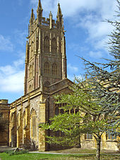
[110][111] The Taunton Minster Church of St Mary Magdalene, built of sandstone more in the South Somerset style, retains an attractive painted interior, but its prime feature is a 15th and 16th-century tower rebuilt in the mid-19th century.
Paul's Meeting survived attempts to turn it into a workhouse, and with the coming of William III and Mary II, followed by the Toleration Act 1688, it reopened.
Initially the side was made up of a mixture of Royal Marines based in Taunton and Exeter with local rugby union players keen to try the 13-man code.