Hurricane Iota
On 7–8 November, the wave turned northwest and traversed northern South America, crossing Guyana, Venezuela, and the Windward Islands before emerging over the Caribbean Sea.
[8] Largely favorable environmental conditions ahead of the disturbance led to the National Hurricane Center (NHC) issuing outlooks for potential cyclogenesis at this time.
Lessening wind shear in this region enabled convection to concentrate around the center of the low and the system became a tropical depression on 13 November, the record-tying thirty-first of the season,[10] approximately 185 mi (298 km) northwest of Aruba.
[8][10][11] Throughout the day, minimal intensification occurred due to vertical wind shear as Iota remained a broad system with its surface- and mid-level circulations disjointed.
[8][12] Large-scale environmental conditions consisting of sea surface temperatures of 84 °F (29 °C) and ample low- to mid-level moisture favored significant intensification of the cyclone.
[13] As Iota moved farther from land on November 14, banding features became more pronounced and deep convection blossomed over a tightening circulation.
The environment surrounding Iota was ideal for this to occur: wind shear fell below 5 mph (8 km/h), lower- to mid-level relative humidity values exceeded 70 percent, and SSTs averaged 84–86 °F (29–30 °C).
[17][nb 2] Iota's core wobbled northwest at the onset of this intensification as the overall trajectory shifted west in response to a strengthening ridge spanning from the western Atlantic to the Gulf of Mexico.
[21] Though not fully understood, hypotheses at the time proposed that eyewall mesovortices can create intense hot towers with strong updrafts capable of more efficiently transporting mass out of the eye.
Around 10:45 UTC the center of Iota passed less than 5 mi (8 km) north of Providencia and Santa Catalina and its eyewall struck the islands directly.
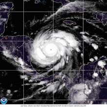
[8] The hurricane's exceptional intensification ended at 12:00 UTC on 16 November with it acquiring maximum sustained winds of 155 mph (249 km/h) and a minimum pressure of 917 mbar (917 hPa; 27.1 inHg).
Lower sea surface temperatures and ocean heat content, likely the result of upwelling from Hurricane Eta, caused convection to diminish and its eye structure to deteriorate.
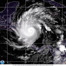
[8][15] Around 03:40 UTC on 17 November, Iota made landfall near the small village of Haulover, Nicaragua (about 25 mi (40 km) south-southwest of Bilwi) with estimated winds of 145 mph (233 km/h).
[27] Based on calculations using the SHIPS inland decay model, Iota is estimated to have degraded to a tropical storm by 18:00 UTC near the Nicaragua-Honduras border.
[30] After weakening to a tropical depression by 12:00 UTC, the surface circulation of Iota dissipated over east-central El Salvador several hours later;[8] however, its mid-level remnant continued west and soon connected to a monsoon trough.
[35] However, in post-analysis, the NHC determined the SFMR values to have a high bias as the highest observations were coupled with lower flight-level winds, a problem that had recently been discovered with other intense hurricanes.
NHC meteorologists determined that breaking waves along the west side of Providencia and Santa Catalina interfered with the instrument's measurement quality.
[40] Oxfam had to temporarily suspend operations across Nicaragua, Honduras, Guatemala, and El Salvador related to Hurricane Eta to protect relief works.
[6] The precursor tropical wave to Iota produced heavy rain across Venezuela's Falcón state, primarily in the Paraguaná Peninsula.
[58] On 15–16 November, Iota passed close to the outlying Archipelago of San Andrés, Providencia and Santa Catalina as a high-end Category 4 hurricane.
[47][59] The center of the hurricane's eye missed Providencia by 11 miles (18 km), but the storm still made a direct hit (rather than a landfall) on the island, causing damage described as "unprecedented" by President Iván Duque Márquez.
[48] Although debris covered runways at El Embrujo Airport, initially preventing aircraft from arriving or leaving,[48] by 17 November it was operational enough to allow President Duque to visit and assess the damage of the island.
[65] Nearly 44,000 homes suffered total or partial damage in Nicaragua, said Nicaraguan Finance Minister Iván Acosta, estimating the storms have cost the country $743 million in losses, according to the government media site El 19.
In Wiwilí, fears arose over the safety of residents who evacuated into the mountains to escape flooding as numerous landslides occurred in the region.
[76] On 23 November a passenger truck plunged off a road in a mountainous area that had been devastated by Iota, an accident which caused the deaths of 17 people and 25 injuries.
[2] Teonela Paisano Wood, the mayor of Brus Laguna, stated concerns that continued rainfall pose a large threat to the town.
[66] The relative lack of casualties in Providencia is attributed to residents adhering to warnings and seeking refuge in sturdy structures or interior bathrooms.
Families will also receive purified water, face masks, blankets, buckets, plastic sheets, eggs and beef (the last two for preferred protein sources).
Additionally, ten health facilities reported a complete loss of cold chain equipment, which hampered preparations made for distribution of COVID-19 vaccines.
[88] Due to the damage and loss of life brought about by the hurricane in Central America, the Greek letter Iota, from the auxiliary storm name list, was retired by the World Meteorological Organization (WMO) in March 2021, and will never be used again for an Atlantic tropical cyclone.

Tropical storm (39–73 mph, 63–118 km/h)
Category 1 (74–95 mph, 119–153 km/h)
Category 2 (96–110 mph, 154–177 km/h)
Category 3 (111–129 mph, 178–208 km/h)
Category 4 (130–156 mph, 209–251 km/h)
Category 5 (≥157 mph, ≥252 km/h)
Unknown