1909 Grand Isle hurricane
Forming out of a tropical disturbance just south of Hispaniola on September 13, 1909, the initial depression slowly intensified as it moved west-northwest towards Jamaica.
After a briefly weakening over land, the system regained strength over the Gulf of Mexico, with peak winds reaching 120 mph (195 km/h) the following day.
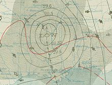
After only slightly weakening, the hurricane increased in forward motion and made landfall near Grand Isle, Louisiana on September 21.
Enhanced by a strong area of high pressure over the Azores and British Isles, the system was able to gradually intensify as it neared the Lesser Antilles.
[2] However, meteorologist José Fernández Partagás stated that there was no evidence of a closed circulation, a key component of tropical cyclones, until September 14.
[2] After reaching this strength, the storm slowed and gradually took a more northwesterly course, heading towards Pinar del Río Province in western Cuba.
Late on September 18, the center of the storm was estimated to have made landfall in Pinar del Río Province with winds of 100 mph (160 km/h); an atmospheric pressure of 976 mbar (hPa; 28.82 inHg) was recorded during its passage.
[2] By the afternoon of September 19, reports from the Louisiana and Mississippi coastline indicated that the outer bands of the hurricane were producing scattered rainfall.
[1] Early on September 21, it was estimated that the center of the hurricane made landfall near Grand Isle, Louisiana with winds of 115 mph (185 km/h).
[8] Once overland, the system quickly weakened, losing hurricane status within 12 hours and later to a tropical depression over southern Missouri.
[1] Amidst rough seas produced by the hurricane, the steamship Nicholas Castina sank off the coast of Cuba, near the Isle of Pines.
Prior to the communication loss, the Weather Bureau reported that waves along the Mississippi River banks were surpassing 3 ft (0.91 m) and water rise in New Orleans itself could reach unprecedented levels.
A total of 306 coal barges sank off the coast of New Orleans and Lobdell (West Baton Rouge Parish), incurring over $1 million in losses.
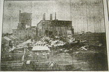
[23] In Natchez, winds up to 50 mph (80 km/h) blew roofs off homes and shut down the local power station, leaving the city in darkness.
Along a 4 mi (6.4 km) stretch of beach in Mississippi, all of the homes and 300 ft (91 m) of the electric car line were destroyed by the hurricane's storm surge.
[24] Further north in Jackson, communication in the city was lost and the dome of the newly constructed capital building was destroyed by high winds.
[18] At the local pier, a ship, named Romanoff, toppled over onto a wharf due to large waves produced by the hurricane.
[1] Although the storm killed more than 370 people in the United States, the National Weather Bureau was credited for "invaluable warnings" prior to the hurricane's arrival, saving many lives.
[25] However, more than four days after the passage of the storm, many other areas devastated by the hurricane had yet to receive aid from either the government or United States Army.
Initially, news reports focused on the large loss of life from the storm but, once the lack of aid was noticed, their attention shifted to the hundreds of survivors who were left homeless and in dire need of basic necessities.
[13] In 2002, the National Oceanic and Atmospheric Administration added the storm surge from the hurricane to the Global Tsunami Database based on newspaper reports referring to the event as a tidal wave.

Tropical storm (39–73 mph, 63–118 km/h)
Category 1 (74–95 mph, 119–153 km/h)
Category 2 (96–110 mph, 154–177 km/h)
Category 3 (111–129 mph, 178–208 km/h)
Category 4 (130–156 mph, 209–251 km/h)
Category 5 (≥157 mph, ≥252 km/h)
Unknown