1916 Virgin Islands hurricane
Rough seas were produced in the Windward Islands at Dominica and Saint Kitts as the storm passed nearby between October 7–8, damaging coastal villages.
On the evening of October 9, the hurricane traversed the Virgin Islands with an intensity equivalent to a Category 2 on the modern Saffir–Simpson scale, passing directly over Saint Croix and producing gusts as high as 160 mph (260 km/h).
Of the Danish West Indies, Saint Thomas fared worst, with virtually every building sustaining damage.
[2] Owing to a paucity of weather observations in the region, the precise location of the storm was not known contemporaneously until it was already traversing the Virgin Islands as a fully-fledged hurricane.
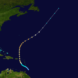
[4] According to a reanalysis of the hurricane in 2008, conducted by the Atlantic Oceanographic and Meteorological Laboratory, the storm began just southeast of Barbados as a tropical depression on October 6.
[1] Curving towards the north,[5] the storm intensified quickly and made landfall on the Danish West Indies at Saint Croix on the evening of October 9.
[9][10] After crossing the islands, the hurricane continued north, its winds increasing further to a peak of 120 mph (190 km/h) southeast of Bermuda on October 12.
[2][5] Inclement weather prevailed over the Windward Islands between October 7–8, yielding the storm's only discernible effects during its unclear origins.
The developing system generated rough seas off Dominica; damaging waves in Roseau advanced well-inland.
[13] Similar seas were reported on the evening of October 8 at Basseterre in Saint Kitts, where waves overtopped the island's seawall.
[17][18] The islands' resources were already strained due to World War I, exacerbating the hurricane's impacts and thwarting measures implemented by the colonial authorities to bolster the economy of the Danish West Indies.
[21] The American consulate in the Danish West Indies sent a cablegram to the U.S. State Department remarking that the hurricane was "the most disastrous known".
[22] Accounts of the hurricane in The Bulletin and Lightbourn's Mail Notes, newsletters in Saint Thomas, made similar judgements, as did American archaeologist Theodoor de Booy.
[13] Beached ships included the ocean liners Calabria and Wasgenwald of the Hamburg America Line and the Danish dredge St.
[33] Calabria and Wasgenwald, both German ships, were interned in the Danish West Indies since the start of World War I.
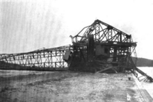
[27] Two electric harbor cranes operated by the West Indian Company and built to withstand a 100-mph (160 km/h) wind were mangled and partially strewn in the sea.
In the market square, trees laid mangled with communication and electric wires,[26] littering public thoroughfares alongside amalgamations of wind-torn gutters and rooftop tiling.
[38] At the supply station of the West India and Panama Telegraph Company, ancillary buildings and storehouses were destroyed.
[39] As more sturdier structures, places of worship fared comparably well but were nevertheless subject to the violence of the winds; rectories were seriously damaged and a chapel was destroyed.
[37] The schooner Vigilant capsized in the Christiansted reef;[43] the ship was raised after sinking in the 1876 San Felipe hurricane only to suffer the same fate in 1916.
[54] HMS Valkyrien embarked on a search-and-rescue operation following the storm, extracting survivors from the stricken barquentine Thor.
[55] The Valkyrien's junior surgeon was sent to Saint John to render assistance due to a lack of any medical personnel on the island.
[56] Galvanized by the devastation wrought by the hurricane, coal carriers—workers who refueled coal-powered ships[57]—in Saint Thomas went on a successful strike to demand increased wages, ultimately forming a union with 2,700 members and negotiating a doubling of their pay.
Tropical storm (39–73 mph, 63–118 km/h)
Category 1 (74–95 mph, 119–153 km/h)
Category 2 (96–110 mph, 154–177 km/h)
Category 3 (111–129 mph, 178–208 km/h)
Category 4 (130–156 mph, 209–251 km/h)
Category 5 (≥157 mph, ≥252 km/h)
Unknown