Geography of Wisconsin
The southwestern part of the state, which was not covered by glaciers during the most recent ice age, is known as the Driftless Area.
Wisconsin has a humid continental climate across the entire state, with four distinct seasons.
Wisconsin is located in the East North Central United States, and is considered to be a part of the Midwest.
The highest temperature ever recorded in the state was in the Wisconsin Dells, on July 13, 1936, where it reached 114 °F (46 °C).
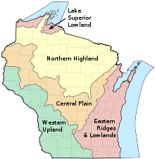
Wisconsin, located between the Great Lakes and the Mississippi River, is home to a wide variety of geographical features.
Lawrence Martin created this schema for dividing the state into geographic regions.
[21] In the middle of the state, the Central Plain has many unique sandstone formations like the Dells of the Wisconsin River, in addition to rich farmland.
The region is generally a flat sandy plain, much of which was covered by Glacial Lake Wisconsin.
[22][23] In the southwest, the Western Upland is a rugged landscape with a mix of forest and farmland, including many bluffs on the Mississippi River.
The Western Upland is part of the Driftless Area, which also includes portions of Iowa, Illinois, and Minnesota.
This area was not covered by glaciers during the most recent ice age, the Wisconsin Glaciation.
[25] The Eastern Ridges and Lowlands region, in the southeast, is home to many of the state's largest cities.
[28] The oldest geologic formations were created over 600 million years ago during the Precambrian, with the majority being below the glacial deposits.
The glaciers flattened mountains, carved bedrock, and deposited sand and gravel in many areas of the state.
The Niagara Escarpment is the longest, running from New York through Ontario, Michigan, Wisconsin, and Illinois.
The name was first recorded as "Meskousing" by Jacques Marquette in 1673, but was later modified to "Ouisconsin" by later French explorers in the 18th century.
[33] The river originates in the Lac Vieux Desert near the border with the Upper Peninsula of Michigan.
The Baraboo River is a tributary, and one of the longest free flowing waterways in the United States.
[44] French Island, in the Mississippi River within the city of La Crosse, covers an area of 2.02 square miles (5.2 km2) and has a population of 4,207.
[46] Washington Island in Lake Michigan is 7 miles (11 km) northeast of the tip of the Door Peninsula.
[47] The Cambrian-Ordovician Aquifer is shallow primarily under Wisconsin but extends into Illinois, Iowa, Indiana, Minnesota, Missouri, and the Upper Peninsula of Michigan.
[51] Chippewa Moraine State Recreation Area covers 3,063 acres (12.40 km2), and preserves numerous glacial landforms.
[54] The state park also includes the 500-foot-high (150 m) quartzite bluffs surrounding the lake, and 11 miles (18 km) of the Ice Age Trail.
[56][57] Wyalusing State Park is located at the confluence of the Wisconsin and Mississippi Rivers, and covers 2,628 acres (10.64 km2).
The principal feature of the forest is the Kettle Moraine, which was created during the Wisconsin Glaciation.